Dirección: 17400 (From 17400 To 17499) 64TH ST SE (Southeast), COLFAX, ND 58018-9609, USA
¿Qué es 58018-9609? 58018-9609 es un Cógido Postal 5 Más 4 de 17400 (From 17400 To 17499) 64TH ST SE (Southeast), COLFAX, ND, USA. La información detallada se muestra abajo.
58018-9609 Información básica

-
Código Postal 5 Más 4:
58018-9609 -
Código Postal 5:
58018 -
Plus 4?96094-digits that are used to identify a geographic segment within the 5-digit delivery area, such as a city block or a group of apartments or an individual high-volume receiver of mail, or any other unit that could use an extra identifier to aid in efficient mail sorting and delivery. This code is the low end of the range of +4 Codes that pertain to this ZIP Code. ZIP+4 Codes associated with nondelivery areas are composed of valid ZIP sector numbers and "ND" for the ZIP segment number, for example 12345-12ND. Non-deliverable areas are areas to which the USPS does not deliver mail, such as vacant lots and land that borders railroad tracks. Mailers should not match an address identified as a nondelivery area. If you absolutely must have numeric characters in the Plus4Code column, you may treat "ND" values as "00" (zero zero).:
-
País:
U.S. - Estados Unidos -
Estado:
ND - Dakota del Norte -
Condado:
CountyFIPS: 38077 - Richland County -
Ciudad:
COLFAX -
Calle?64TH STThe official name of a street as assigned by a local governing authority. The Street Name column contains only the street name and does not include directionals (EAST, WEST, etc.) or suffixes (ST, DR, BLVD, etc.). This element may also contain literals, such as PO BOX, GENERAL DELIVERY, USS, PSC, or UNIT. Numeric street names that have numeric components that are four characters (or less) in length at are justified such that the low-order digit of the number is positioned in the fourth position of the street name column. This shift is made so that the numeric street names appear in numeric sequence.:
-
Sufijo de Calle?ST (Calle)The street suffix: For Example: ST = Street RD = Road DR = Drive LN = Lane:
-
Postdireccional de Calle?SE (Southeast)A geographic direction that precedes the street name. For Example: 472 MAIN ST N Street Pre-Direction Abbreviation = N Spaces = No pre-direction N = North NE = Northeast E = East SE = Southeast S = South SW = Southwest W = West NW = Northwest:
-
Tipo de Registro?S: CalleAn alphabetic value that identifies the type of data in the record. Record type codes include the following: G = General delivery H = Highrise F = Firm S = Street P = PO box R = Rural route/highway contract:
Dirección

- Número Bajo Primario de Dirección?
A house, rural route, highway contract box, or post office box number; the numeric or alphanumeric component of an address preceding the street name; the low-end address in a range of addresses. Often referred to as house number.: 17400
- Número Alto Primario de Dirección?
A house, rural route, contract box, or Post Office box number. The numeric or alphanumeric component of an address preceding the street name. The high-end address in a range of addresses. Often referred to as house number.: 17499
- Código Impar / Par Primario de Dirección?
Code that identifies the side or sides of a street for which a given address range is applicable. For street, highrise, firm and multi-carrier records, B = Both sides of a street, E = Even side of a street (even-numbered addresses in the range); O = Odd side of a street (odd-numbered addresses in the range). For general delivery, post office box, and rural route/highway contract records, this code will always be "B" (both).: Both of Odd and Even
- Primario Alcance: 17400, 17401, 17402, 17403, 17404, 17405, 17406, 17407, 17408, 17409, 17410, 17411, 17412, 17413, 17414, 17415, 17416, 17417, 17418, 17419, 17420, 17421, 17422, 17423, 17424, 17425, 17426, 17427, 17428, 17429, 17430, 17431, 17432, 17433, 17434, 17435, 17436, 17437, 17438, 17439, 17440, 17441, 17442, 17443, 17444, 17445, 17446, 17447, 17448, 17449, 17450, 17451, 17452, 17453, 17454, 17455, 17456, 17457, 17458, 17459, 17460, 17461, 17462, 17463, 17464, 17465, 17466, 17467, 17468, 17469, 17470, 17471, 17472, 17473, 17474, 17475, 17476, 17477, 17478, 17479, 17480, 17481, 17482, 17483, 17484, 17485, 17486, 17487, 17488, 17489, 17490, 17491, 17492, 17493, 17494, 17495, 17496, 17497, 17498, 17499.
Haga clic en "Más ejemplos de direcciones" para ver la lista completa.
17400 64TH ST SE (Southeast), COLFAX, ND 58018-9609
17401 64TH ST SE (Southeast), COLFAX, ND 58018-9609
17402 64TH ST SE (Southeast), COLFAX, ND 58018-9609
17403 64TH ST SE (Southeast), COLFAX, ND 58018-9609
17404 64TH ST SE (Southeast), COLFAX, ND 58018-9609
17405 64TH ST SE (Southeast), COLFAX, ND 58018-9609
17406 64TH ST SE (Southeast), COLFAX, ND 58018-9609
17407 64TH ST SE (Southeast), COLFAX, ND 58018-9609
17408 64TH ST SE (Southeast), COLFAX, ND 58018-9609
17409 64TH ST SE (Southeast), COLFAX, ND 58018-9609
17410 64TH ST SE (Southeast), COLFAX, ND 58018-9609
17411 64TH ST SE (Southeast), COLFAX, ND 58018-9609
17412 64TH ST SE (Southeast), COLFAX, ND 58018-9609
17413 64TH ST SE (Southeast), COLFAX, ND 58018-9609
17414 64TH ST SE (Southeast), COLFAX, ND 58018-9609
17415 64TH ST SE (Southeast), COLFAX, ND 58018-9609
17416 64TH ST SE (Southeast), COLFAX, ND 58018-9609
17417 64TH ST SE (Southeast), COLFAX, ND 58018-9609
17418 64TH ST SE (Southeast), COLFAX, ND 58018-9609
17419 64TH ST SE (Southeast), COLFAX, ND 58018-9609
17420 64TH ST SE (Southeast), COLFAX, ND 58018-9609
17421 64TH ST SE (Southeast), COLFAX, ND 58018-9609
17422 64TH ST SE (Southeast), COLFAX, ND 58018-9609
17423 64TH ST SE (Southeast), COLFAX, ND 58018-9609
17424 64TH ST SE (Southeast), COLFAX, ND 58018-9609
17425 64TH ST SE (Southeast), COLFAX, ND 58018-9609
17426 64TH ST SE (Southeast), COLFAX, ND 58018-9609
17427 64TH ST SE (Southeast), COLFAX, ND 58018-9609
17428 64TH ST SE (Southeast), COLFAX, ND 58018-9609
17429 64TH ST SE (Southeast), COLFAX, ND 58018-9609
17430 64TH ST SE (Southeast), COLFAX, ND 58018-9609
17431 64TH ST SE (Southeast), COLFAX, ND 58018-9609
17432 64TH ST SE (Southeast), COLFAX, ND 58018-9609
17433 64TH ST SE (Southeast), COLFAX, ND 58018-9609
17434 64TH ST SE (Southeast), COLFAX, ND 58018-9609
17435 64TH ST SE (Southeast), COLFAX, ND 58018-9609
17436 64TH ST SE (Southeast), COLFAX, ND 58018-9609
17437 64TH ST SE (Southeast), COLFAX, ND 58018-9609
17438 64TH ST SE (Southeast), COLFAX, ND 58018-9609
17439 64TH ST SE (Southeast), COLFAX, ND 58018-9609
17440 64TH ST SE (Southeast), COLFAX, ND 58018-9609
17441 64TH ST SE (Southeast), COLFAX, ND 58018-9609
17442 64TH ST SE (Southeast), COLFAX, ND 58018-9609
17443 64TH ST SE (Southeast), COLFAX, ND 58018-9609
17444 64TH ST SE (Southeast), COLFAX, ND 58018-9609
17445 64TH ST SE (Southeast), COLFAX, ND 58018-9609
17446 64TH ST SE (Southeast), COLFAX, ND 58018-9609
17447 64TH ST SE (Southeast), COLFAX, ND 58018-9609
17448 64TH ST SE (Southeast), COLFAX, ND 58018-9609
17449 64TH ST SE (Southeast), COLFAX, ND 58018-9609
17450 64TH ST SE (Southeast), COLFAX, ND 58018-9609
17451 64TH ST SE (Southeast), COLFAX, ND 58018-9609
17452 64TH ST SE (Southeast), COLFAX, ND 58018-9609
17453 64TH ST SE (Southeast), COLFAX, ND 58018-9609
17454 64TH ST SE (Southeast), COLFAX, ND 58018-9609
17455 64TH ST SE (Southeast), COLFAX, ND 58018-9609
17456 64TH ST SE (Southeast), COLFAX, ND 58018-9609
17457 64TH ST SE (Southeast), COLFAX, ND 58018-9609
17458 64TH ST SE (Southeast), COLFAX, ND 58018-9609
17459 64TH ST SE (Southeast), COLFAX, ND 58018-9609
17460 64TH ST SE (Southeast), COLFAX, ND 58018-9609
17461 64TH ST SE (Southeast), COLFAX, ND 58018-9609
17462 64TH ST SE (Southeast), COLFAX, ND 58018-9609
17463 64TH ST SE (Southeast), COLFAX, ND 58018-9609
17464 64TH ST SE (Southeast), COLFAX, ND 58018-9609
17465 64TH ST SE (Southeast), COLFAX, ND 58018-9609
17466 64TH ST SE (Southeast), COLFAX, ND 58018-9609
17467 64TH ST SE (Southeast), COLFAX, ND 58018-9609
17468 64TH ST SE (Southeast), COLFAX, ND 58018-9609
17469 64TH ST SE (Southeast), COLFAX, ND 58018-9609
17470 64TH ST SE (Southeast), COLFAX, ND 58018-9609
17471 64TH ST SE (Southeast), COLFAX, ND 58018-9609
17472 64TH ST SE (Southeast), COLFAX, ND 58018-9609
17473 64TH ST SE (Southeast), COLFAX, ND 58018-9609
17474 64TH ST SE (Southeast), COLFAX, ND 58018-9609
17475 64TH ST SE (Southeast), COLFAX, ND 58018-9609
17476 64TH ST SE (Southeast), COLFAX, ND 58018-9609
17477 64TH ST SE (Southeast), COLFAX, ND 58018-9609
17478 64TH ST SE (Southeast), COLFAX, ND 58018-9609
17479 64TH ST SE (Southeast), COLFAX, ND 58018-9609
17480 64TH ST SE (Southeast), COLFAX, ND 58018-9609
17481 64TH ST SE (Southeast), COLFAX, ND 58018-9609
17482 64TH ST SE (Southeast), COLFAX, ND 58018-9609
17483 64TH ST SE (Southeast), COLFAX, ND 58018-9609
17484 64TH ST SE (Southeast), COLFAX, ND 58018-9609
17485 64TH ST SE (Southeast), COLFAX, ND 58018-9609
17486 64TH ST SE (Southeast), COLFAX, ND 58018-9609
17487 64TH ST SE (Southeast), COLFAX, ND 58018-9609
17488 64TH ST SE (Southeast), COLFAX, ND 58018-9609
17489 64TH ST SE (Southeast), COLFAX, ND 58018-9609
17490 64TH ST SE (Southeast), COLFAX, ND 58018-9609
17491 64TH ST SE (Southeast), COLFAX, ND 58018-9609
17492 64TH ST SE (Southeast), COLFAX, ND 58018-9609
17493 64TH ST SE (Southeast), COLFAX, ND 58018-9609
17494 64TH ST SE (Southeast), COLFAX, ND 58018-9609
17495 64TH ST SE (Southeast), COLFAX, ND 58018-9609
17496 64TH ST SE (Southeast), COLFAX, ND 58018-9609
17497 64TH ST SE (Southeast), COLFAX, ND 58018-9609
17498 64TH ST SE (Southeast), COLFAX, ND 58018-9609
17499 64TH ST SE (Southeast), COLFAX, ND 58018-9609
Dirección Ejemplo
COLFAX ND 58018-9609
UNITED STATES OF AMERICA
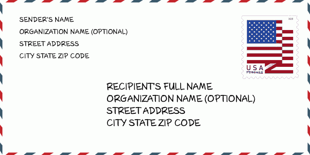
58018-9609 Ejemplo de Sobre

-
Este es un ejemplo de sobre estadounidense. Complete la información del remitente en la parte superior izquierda y la información del destinatario en la parte inferior derecha. La información necesaria es el nombre completo del remitente / destinatario, la dirección postal, la ciudad, el estado y el código postal. La información de la dirección del destinatario se ha proporcionado para su referencia. Generalmente, si no está seguro del código postal completo de 9 dígitos, solo puede completar el código postal de 5 dígitos para evitar la pérdida del paquete.
58018-9609 Significado básico
-
¿Qué significa cada dígito del código postal 58018-9609? El código postal + 4 consta de dos partes, los primeros cinco dígitos se pueden ubicar en la oficina postal y los últimos cuatro dígitos pueden identificar un segmento geográfico dentro del área de entrega de cinco dígitos. Los 6-7 dígitos designan un sector o varios bloques, y los 8-9 dígitos designan un segmento o un lado de una calle.
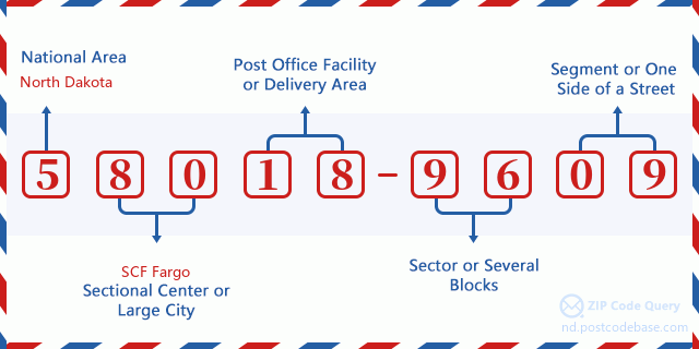

- ·ID de Ruta de Transportador?
A 4-digit code assigned to a mail delivery or collection route within a 5-digit ZIP Code. The first character of this identification is alphabetical, and the last three are numeric: Bnnn = PO box Hnnn = Highway contract Rnnn = Rural route Cnnn = City delivery Gnnn = General delivery: R001 (Ruta Rural)
- ·Sector Bajo de Agregar Código Postal?
The ZIP Add-On Low Sector and the ZIP Add-On Low Segment together form the ZIP Add-On Low Number. The ZIP Add-On Low Number is the last four positions of a ZIP+4 code; the low-end ZIP add-on in a range of codes; the add-on of the first ZIP+4 code in a consecutive series of ZIP+4 codes assigned to the delivery address. For example, most delivery addresses are assigned a single ZIP+4 code. However, large companies may be given a range of ZIP+4 codes that can be used to route mail to specific departments. A range of ZIP+4 codes can also be assigned to a corresponding range of post office boxes, and each box is mapped, one-to-one, with a ZIP+4 code in the range. A single post office box can also be assigned a range of ZIP+4 codes.: 96
- ·Segmento Bajo de Agregar Código Postal?
The ZIP Add-On Low Sector and the ZIP Add-On Low Segment together form the ZIP Add-On Low Number. The ZIP Add-On Low Number is the last four positions of a ZIP+4 code; the low-end ZIP add-on in a range of codes; the add-on of the first ZIP+4 code in a consecutive series of ZIP+4 codes assigned to the delivery address. For example, most delivery addresses are assigned a single ZIP+4 code. However, large companies may be given a range of ZIP+4 codes that can be used to route mail to specific departments. A range of ZIP+4 codes can also be assigned to a corresponding range of post office boxes, and each box is mapped, one-to-one, with a ZIP+4 code in the range. A single post office box can also be assigned a range of ZIP+4 codes.: 09
- ·Sector Alto de Agregar Código Postal?
The ZIP Add-On High Sector and the ZIP Add-On High Segment together form the ZIP Add-On High Number, which is the high-end ZIP add-on in a range of codes; the add-on of the last ZIP+4 code in a consecutive series of ZIP+4 codes assigned to the delivery address. Most delivery addresses are assigned a single ZIP+4 code; however, large companies may be given a range of ZIP+4 codes that can be used to route mail to specific departments. A range of ZIP+4 codes can also be assigned to a corresponding range of post office boxes, and each box is mapped, one-to-one, with a ZIP+4 code in the range. A single post office box can also be assigned a range of ZIP+4 codes. (See also ZIP Add-On Code.): 96
- ·Segmento Alto de Agregar Código Postal?
The ZIP Add-On High Sector and the ZIP Add-On High Segment together form the ZIP Add-On High Number, which is the high-end ZIP add-on in a range of codes; the add-on of the last ZIP+4 code in a consecutive series of ZIP+4 codes assigned to the delivery address. Most delivery addresses are assigned a single ZIP+4 code; however, large companies may be given a range of ZIP+4 codes that can be used to route mail to specific departments. A range of ZIP+4 codes can also be assigned to a corresponding range of post office boxes, and each box is mapped, one-to-one, with a ZIP+4 code in the range. A single post office box can also be assigned a range of ZIP+4 codes. (See also ZIP Add-On Code.): 09
- ·Código Postal Añadir: 9609
- ·Alcance?
The range of +4 codes. Summing the +4 Code and the +4 Range will give you the high end of the range of +4 Codes that pertain to this ZIP Code.: 0
- ·Código Alternativo de Base?
Code that specifies whether a record is a base (preferred) or alternate record. Base records (represented as "B") can represent a range of addresses or an individual address, such as a firm record, while alternate records (represented as "A") are individual delivery points. Government deliveries will only be listed on alternate records with the appropriate government building indicator (federal, state, or city) set.: Base
- ·Número Financiero?
A code assigned to Postal Service facilities (primarily post offices) to collect cost and statistical data and compile revenue and expense data. The state number comprises the first two positions of the finance number.: 371872
- ·Número de Distrito del Congreso?
A standard value identifying a geographic area within the United States served by a member of the US House of Representatives or Senate. If Army/Air Force (APO) or fleet post office (FPO), this column will be blank. If there is only one member of Congress within a state, the code will be "AL" (at large).: AL
- ·Código de Estado de Ciudad de Línea Preferida?
An index to the City State file that provides the preferred last-line name for this address range.: W18825
Mapa en Línea

Esto es el mapa en línea de la dirección 17400 64TH ST, COLFAX. Podría utilizar el botón para moverse y acercarse / alejarse. La información del mapa sirve sólo como referencia.
Dirección: 17400 (From 17400 To 17499) 64TH ST SE (Southeast), COLFAX, ND 58018-9609, USA
Comentario


Añadir nuevo comentario