نشانی: 16200 (From 16200 To 16299) COUNTY ROAD 10, BARNEY, ND 58008-9635, USA
؟58008-9635 چیست 58008-9635 یک کد فشرده 5 به همراه 4 عدد از 16200 (From 16200 To 16299) COUNTY ROAD 10, BARNEY, ND, USA است. اطلاعات بیشتر در زیر آمده است.
58008-9635 اطلاعات اولیه

-
کد پستی 5 به علاوه 4:
58008-9635 -
کد پستی 5:
58008 -
به علاوه 4?96354-digits that are used to identify a geographic segment within the 5-digit delivery area, such as a city block or a group of apartments or an individual high-volume receiver of mail, or any other unit that could use an extra identifier to aid in efficient mail sorting and delivery. This code is the low end of the range of +4 Codes that pertain to this ZIP Code. ZIP+4 Codes associated with nondelivery areas are composed of valid ZIP sector numbers and "ND" for the ZIP segment number, for example 12345-12ND. Non-deliverable areas are areas to which the USPS does not deliver mail, such as vacant lots and land that borders railroad tracks. Mailers should not match an address identified as a nondelivery area. If you absolutely must have numeric characters in the Plus4Code column, you may treat "ND" values as "00" (zero zero).:
-
کشور:
U.S. - ایالات متحده -
دولت:
ND - داکوتای شمالی -
شهرستان:
CountyFIPS: 38077 - Richland County -
شهر:
BARNEY -
خیابان?COUNTY ROAD 10The official name of a street as assigned by a local governing authority. The Street Name column contains only the street name and does not include directionals (EAST, WEST, etc.) or suffixes (ST, DR, BLVD, etc.). This element may also contain literals, such as PO BOX, GENERAL DELIVERY, USS, PSC, or UNIT. Numeric street names that have numeric components that are four characters (or less) in length at are justified such that the low-order digit of the number is positioned in the fourth position of the street name column. This shift is made so that the numeric street names appear in numeric sequence.:
-
نوع ثبت?S: خیابانAn alphabetic value that identifies the type of data in the record. Record type codes include the following: G = General delivery H = Highrise F = Firm S = Street P = PO box R = Rural route/highway contract:
نشانی

- شماره پایین آدرس اولیه?
A house, rural route, highway contract box, or post office box number; the numeric or alphanumeric component of an address preceding the street name; the low-end address in a range of addresses. Often referred to as house number.: 16200
- شماره بالا آدرس اولیه?
A house, rural route, contract box, or Post Office box number. The numeric or alphanumeric component of an address preceding the street name. The high-end address in a range of addresses. Often referred to as house number.: 16299
- کد فرد/ زوج آدرس اولیه?
Code that identifies the side or sides of a street for which a given address range is applicable. For street, highrise, firm and multi-carrier records, B = Both sides of a street, E = Even side of a street (even-numbered addresses in the range); O = Odd side of a street (odd-numbered addresses in the range). For general delivery, post office box, and rural route/highway contract records, this code will always be "B" (both).: Both of Odd and Even
- اولیه محدوده: 16200, 16201, 16202, 16203, 16204, 16205, 16206, 16207, 16208, 16209, 16210, 16211, 16212, 16213, 16214, 16215, 16216, 16217, 16218, 16219, 16220, 16221, 16222, 16223, 16224, 16225, 16226, 16227, 16228, 16229, 16230, 16231, 16232, 16233, 16234, 16235, 16236, 16237, 16238, 16239, 16240, 16241, 16242, 16243, 16244, 16245, 16246, 16247, 16248, 16249, 16250, 16251, 16252, 16253, 16254, 16255, 16256, 16257, 16258, 16259, 16260, 16261, 16262, 16263, 16264, 16265, 16266, 16267, 16268, 16269, 16270, 16271, 16272, 16273, 16274, 16275, 16276, 16277, 16278, 16279, 16280, 16281, 16282, 16283, 16284, 16285, 16286, 16287, 16288, 16289, 16290, 16291, 16292, 16293, 16294, 16295, 16296, 16297, 16298, 16299.
لطفاً برای مشاهده کل لیست ، بر روی "نمونه های آدرس بیشتر" کلیک کنید.
16200 COUNTY ROAD 10, BARNEY, ND 58008-9635
16201 COUNTY ROAD 10, BARNEY, ND 58008-9635
16202 COUNTY ROAD 10, BARNEY, ND 58008-9635
16203 COUNTY ROAD 10, BARNEY, ND 58008-9635
16204 COUNTY ROAD 10, BARNEY, ND 58008-9635
16205 COUNTY ROAD 10, BARNEY, ND 58008-9635
16206 COUNTY ROAD 10, BARNEY, ND 58008-9635
16207 COUNTY ROAD 10, BARNEY, ND 58008-9635
16208 COUNTY ROAD 10, BARNEY, ND 58008-9635
16209 COUNTY ROAD 10, BARNEY, ND 58008-9635
16210 COUNTY ROAD 10, BARNEY, ND 58008-9635
16211 COUNTY ROAD 10, BARNEY, ND 58008-9635
16212 COUNTY ROAD 10, BARNEY, ND 58008-9635
16213 COUNTY ROAD 10, BARNEY, ND 58008-9635
16214 COUNTY ROAD 10, BARNEY, ND 58008-9635
16215 COUNTY ROAD 10, BARNEY, ND 58008-9635
16216 COUNTY ROAD 10, BARNEY, ND 58008-9635
16217 COUNTY ROAD 10, BARNEY, ND 58008-9635
16218 COUNTY ROAD 10, BARNEY, ND 58008-9635
16219 COUNTY ROAD 10, BARNEY, ND 58008-9635
16220 COUNTY ROAD 10, BARNEY, ND 58008-9635
16221 COUNTY ROAD 10, BARNEY, ND 58008-9635
16222 COUNTY ROAD 10, BARNEY, ND 58008-9635
16223 COUNTY ROAD 10, BARNEY, ND 58008-9635
16224 COUNTY ROAD 10, BARNEY, ND 58008-9635
16225 COUNTY ROAD 10, BARNEY, ND 58008-9635
16226 COUNTY ROAD 10, BARNEY, ND 58008-9635
16227 COUNTY ROAD 10, BARNEY, ND 58008-9635
16228 COUNTY ROAD 10, BARNEY, ND 58008-9635
16229 COUNTY ROAD 10, BARNEY, ND 58008-9635
16230 COUNTY ROAD 10, BARNEY, ND 58008-9635
16231 COUNTY ROAD 10, BARNEY, ND 58008-9635
16232 COUNTY ROAD 10, BARNEY, ND 58008-9635
16233 COUNTY ROAD 10, BARNEY, ND 58008-9635
16234 COUNTY ROAD 10, BARNEY, ND 58008-9635
16235 COUNTY ROAD 10, BARNEY, ND 58008-9635
16236 COUNTY ROAD 10, BARNEY, ND 58008-9635
16237 COUNTY ROAD 10, BARNEY, ND 58008-9635
16238 COUNTY ROAD 10, BARNEY, ND 58008-9635
16239 COUNTY ROAD 10, BARNEY, ND 58008-9635
16240 COUNTY ROAD 10, BARNEY, ND 58008-9635
16241 COUNTY ROAD 10, BARNEY, ND 58008-9635
16242 COUNTY ROAD 10, BARNEY, ND 58008-9635
16243 COUNTY ROAD 10, BARNEY, ND 58008-9635
16244 COUNTY ROAD 10, BARNEY, ND 58008-9635
16245 COUNTY ROAD 10, BARNEY, ND 58008-9635
16246 COUNTY ROAD 10, BARNEY, ND 58008-9635
16247 COUNTY ROAD 10, BARNEY, ND 58008-9635
16248 COUNTY ROAD 10, BARNEY, ND 58008-9635
16249 COUNTY ROAD 10, BARNEY, ND 58008-9635
16250 COUNTY ROAD 10, BARNEY, ND 58008-9635
16251 COUNTY ROAD 10, BARNEY, ND 58008-9635
16252 COUNTY ROAD 10, BARNEY, ND 58008-9635
16253 COUNTY ROAD 10, BARNEY, ND 58008-9635
16254 COUNTY ROAD 10, BARNEY, ND 58008-9635
16255 COUNTY ROAD 10, BARNEY, ND 58008-9635
16256 COUNTY ROAD 10, BARNEY, ND 58008-9635
16257 COUNTY ROAD 10, BARNEY, ND 58008-9635
16258 COUNTY ROAD 10, BARNEY, ND 58008-9635
16259 COUNTY ROAD 10, BARNEY, ND 58008-9635
16260 COUNTY ROAD 10, BARNEY, ND 58008-9635
16261 COUNTY ROAD 10, BARNEY, ND 58008-9635
16262 COUNTY ROAD 10, BARNEY, ND 58008-9635
16263 COUNTY ROAD 10, BARNEY, ND 58008-9635
16264 COUNTY ROAD 10, BARNEY, ND 58008-9635
16265 COUNTY ROAD 10, BARNEY, ND 58008-9635
16266 COUNTY ROAD 10, BARNEY, ND 58008-9635
16267 COUNTY ROAD 10, BARNEY, ND 58008-9635
16268 COUNTY ROAD 10, BARNEY, ND 58008-9635
16269 COUNTY ROAD 10, BARNEY, ND 58008-9635
16270 COUNTY ROAD 10, BARNEY, ND 58008-9635
16271 COUNTY ROAD 10, BARNEY, ND 58008-9635
16272 COUNTY ROAD 10, BARNEY, ND 58008-9635
16273 COUNTY ROAD 10, BARNEY, ND 58008-9635
16274 COUNTY ROAD 10, BARNEY, ND 58008-9635
16275 COUNTY ROAD 10, BARNEY, ND 58008-9635
16276 COUNTY ROAD 10, BARNEY, ND 58008-9635
16277 COUNTY ROAD 10, BARNEY, ND 58008-9635
16278 COUNTY ROAD 10, BARNEY, ND 58008-9635
16279 COUNTY ROAD 10, BARNEY, ND 58008-9635
16280 COUNTY ROAD 10, BARNEY, ND 58008-9635
16281 COUNTY ROAD 10, BARNEY, ND 58008-9635
16282 COUNTY ROAD 10, BARNEY, ND 58008-9635
16283 COUNTY ROAD 10, BARNEY, ND 58008-9635
16284 COUNTY ROAD 10, BARNEY, ND 58008-9635
16285 COUNTY ROAD 10, BARNEY, ND 58008-9635
16286 COUNTY ROAD 10, BARNEY, ND 58008-9635
16287 COUNTY ROAD 10, BARNEY, ND 58008-9635
16288 COUNTY ROAD 10, BARNEY, ND 58008-9635
16289 COUNTY ROAD 10, BARNEY, ND 58008-9635
16290 COUNTY ROAD 10, BARNEY, ND 58008-9635
16291 COUNTY ROAD 10, BARNEY, ND 58008-9635
16292 COUNTY ROAD 10, BARNEY, ND 58008-9635
16293 COUNTY ROAD 10, BARNEY, ND 58008-9635
16294 COUNTY ROAD 10, BARNEY, ND 58008-9635
16295 COUNTY ROAD 10, BARNEY, ND 58008-9635
16296 COUNTY ROAD 10, BARNEY, ND 58008-9635
16297 COUNTY ROAD 10, BARNEY, ND 58008-9635
16298 COUNTY ROAD 10, BARNEY, ND 58008-9635
16299 COUNTY ROAD 10, BARNEY, ND 58008-9635
نشانی مثال
BARNEY ND 58008-9635
UNITED STATES OF AMERICA
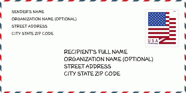
58008-9635 نمونه پاکت

-
این نمونه ای از پاکت نامه ایالات متحده است. اطلاعات فرستنده را در بالا سمت چپ و اطلاعات گیرنده را در پایین سمت راست وارد کنید. اطلاعات لازم نام کامل فرستنده/گیرنده ، آدرس خیابان ، شهر ، ایالت و کد پستی است. اطلاعات آدرس گیرنده برای مرجع شما داده شده است. به طور کلی ، اگر از کد پستی کامل 9 رقمی مطمئن نیستید ، فقط می توانید کد پستی 5 رقمی را پر کنید تا از دست دادن بسته جلوگیری شود.
58008-9635 معنای اساسی
-
هر رقم کد پستی 58008-9635 مخفف چیست؟ کد ZIP+4 از دو بخش تشکیل شده است، پنج رقم اول را می توان در اداره پست قرار داد، و چهار رقم آخر می تواند یک بخش جغرافیایی را در منطقه تحویل پنج رقمی مشخص کند. 6-7 رقم بخش یا چند بلوک را مشخص می کند و رقم 8-9 نشان دهنده بخش یا یک طرف خیابان است.
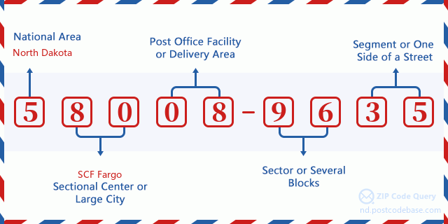

- ·شناسایی مسیر حامل?
A 4-digit code assigned to a mail delivery or collection route within a 5-digit ZIP Code. The first character of this identification is alphabetical, and the last three are numeric: Bnnn = PO box Hnnn = Highway contract Rnnn = Rural route Cnnn = City delivery Gnnn = General delivery: R001 (مسیر روستایی)
- ·بخش پایین افزونه فشرده?
The ZIP Add-On Low Sector and the ZIP Add-On Low Segment together form the ZIP Add-On Low Number. The ZIP Add-On Low Number is the last four positions of a ZIP+4 code; the low-end ZIP add-on in a range of codes; the add-on of the first ZIP+4 code in a consecutive series of ZIP+4 codes assigned to the delivery address. For example, most delivery addresses are assigned a single ZIP+4 code. However, large companies may be given a range of ZIP+4 codes that can be used to route mail to specific departments. A range of ZIP+4 codes can also be assigned to a corresponding range of post office boxes, and each box is mapped, one-to-one, with a ZIP+4 code in the range. A single post office box can also be assigned a range of ZIP+4 codes.: 96
- ·بخش پایین افزونه فشرده?
The ZIP Add-On Low Sector and the ZIP Add-On Low Segment together form the ZIP Add-On Low Number. The ZIP Add-On Low Number is the last four positions of a ZIP+4 code; the low-end ZIP add-on in a range of codes; the add-on of the first ZIP+4 code in a consecutive series of ZIP+4 codes assigned to the delivery address. For example, most delivery addresses are assigned a single ZIP+4 code. However, large companies may be given a range of ZIP+4 codes that can be used to route mail to specific departments. A range of ZIP+4 codes can also be assigned to a corresponding range of post office boxes, and each box is mapped, one-to-one, with a ZIP+4 code in the range. A single post office box can also be assigned a range of ZIP+4 codes.: 35
- ·بخش بالا افزونه فشرده?
The ZIP Add-On High Sector and the ZIP Add-On High Segment together form the ZIP Add-On High Number, which is the high-end ZIP add-on in a range of codes; the add-on of the last ZIP+4 code in a consecutive series of ZIP+4 codes assigned to the delivery address. Most delivery addresses are assigned a single ZIP+4 code; however, large companies may be given a range of ZIP+4 codes that can be used to route mail to specific departments. A range of ZIP+4 codes can also be assigned to a corresponding range of post office boxes, and each box is mapped, one-to-one, with a ZIP+4 code in the range. A single post office box can also be assigned a range of ZIP+4 codes. (See also ZIP Add-On Code.): 96
- ·بخش بالا افزونه فشرده?
The ZIP Add-On High Sector and the ZIP Add-On High Segment together form the ZIP Add-On High Number, which is the high-end ZIP add-on in a range of codes; the add-on of the last ZIP+4 code in a consecutive series of ZIP+4 codes assigned to the delivery address. Most delivery addresses are assigned a single ZIP+4 code; however, large companies may be given a range of ZIP+4 codes that can be used to route mail to specific departments. A range of ZIP+4 codes can also be assigned to a corresponding range of post office boxes, and each box is mapped, one-to-one, with a ZIP+4 code in the range. A single post office box can also be assigned a range of ZIP+4 codes. (See also ZIP Add-On Code.): 35
- ·کد پستی افزونه: 9635
- ·محدوده?
The range of +4 codes. Summing the +4 Code and the +4 Range will give you the high end of the range of +4 Codes that pertain to this ZIP Code.: 0
- ·کد متناوب پایه?
Code that specifies whether a record is a base (preferred) or alternate record. Base records (represented as "B") can represent a range of addresses or an individual address, such as a firm record, while alternate records (represented as "A") are individual delivery points. Government deliveries will only be listed on alternate records with the appropriate government building indicator (federal, state, or city) set.: پایه
- ·شماره مالی?
A code assigned to Postal Service facilities (primarily post offices) to collect cost and statistical data and compile revenue and expense data. The state number comprises the first two positions of the finance number.: 379488
- ·شماره ناحیه کنگره?
A standard value identifying a geographic area within the United States served by a member of the US House of Representatives or Senate. If Army/Air Force (APO) or fleet post office (FPO), this column will be blank. If there is only one member of Congress within a state, the code will be "AL" (at large).: AL
- ·کلید دولتی خط نهایی ترجیحی?
An index to the City State file that provides the preferred last-line name for this address range.: 017584
نقشه آنلاین

این نقشه آنلاین آدرس 16200 COUNTY ROAD 10 BARNEY است. برای حرکت و زوم میتوانید از دکمه استفاده کنید. اطلاعات نقشه تنها برای مرجع است.
نشانی: 16200 (From 16200 To 16299) COUNTY ROAD 10, BARNEY, ND 58008-9635, USA
دیدگاه


افزودن دیدگاه جدید