نشانی: 6400 (From 6400 To 6499) 172ND AVE SE (Southeast), COLFAX, ND 58018-9604, USA
؟58018-9604 چیست 58018-9604 یک کد فشرده 5 به همراه 4 عدد از 6400 (From 6400 To 6499) 172ND AVE SE (Southeast), COLFAX, ND, USA است. اطلاعات بیشتر در زیر آمده است.
58018-9604 اطلاعات اولیه

-
کد پستی 5 به علاوه 4:
58018-9604 -
کد پستی 5:
58018 -
به علاوه 4?96044-digits that are used to identify a geographic segment within the 5-digit delivery area, such as a city block or a group of apartments or an individual high-volume receiver of mail, or any other unit that could use an extra identifier to aid in efficient mail sorting and delivery. This code is the low end of the range of +4 Codes that pertain to this ZIP Code. ZIP+4 Codes associated with nondelivery areas are composed of valid ZIP sector numbers and "ND" for the ZIP segment number, for example 12345-12ND. Non-deliverable areas are areas to which the USPS does not deliver mail, such as vacant lots and land that borders railroad tracks. Mailers should not match an address identified as a nondelivery area. If you absolutely must have numeric characters in the Plus4Code column, you may treat "ND" values as "00" (zero zero).:
-
کشور:
U.S. - ایالات متحده -
دولت:
ND - داکوتای شمالی -
شهرستان:
CountyFIPS: 38077 - Richland County -
شهر:
COLFAX -
خیابان?172ND AVEThe official name of a street as assigned by a local governing authority. The Street Name column contains only the street name and does not include directionals (EAST, WEST, etc.) or suffixes (ST, DR, BLVD, etc.). This element may also contain literals, such as PO BOX, GENERAL DELIVERY, USS, PSC, or UNIT. Numeric street names that have numeric components that are four characters (or less) in length at are justified such that the low-order digit of the number is positioned in the fourth position of the street name column. This shift is made so that the numeric street names appear in numeric sequence.:
-
پسوند خیابان?AVE (خیابان)The street suffix: For Example: ST = Street RD = Road DR = Drive LN = Lane:
-
پسمسیر خیابان?SE (Southeast)A geographic direction that precedes the street name. For Example: 472 MAIN ST N Street Pre-Direction Abbreviation = N Spaces = No pre-direction N = North NE = Northeast E = East SE = Southeast S = South SW = Southwest W = West NW = Northwest:
-
نوع ثبت?S: خیابانAn alphabetic value that identifies the type of data in the record. Record type codes include the following: G = General delivery H = Highrise F = Firm S = Street P = PO box R = Rural route/highway contract:
نشانی

- شماره پایین آدرس اولیه?
A house, rural route, highway contract box, or post office box number; the numeric or alphanumeric component of an address preceding the street name; the low-end address in a range of addresses. Often referred to as house number.: 6400
- شماره بالا آدرس اولیه?
A house, rural route, contract box, or Post Office box number. The numeric or alphanumeric component of an address preceding the street name. The high-end address in a range of addresses. Often referred to as house number.: 6499
- کد فرد/ زوج آدرس اولیه?
Code that identifies the side or sides of a street for which a given address range is applicable. For street, highrise, firm and multi-carrier records, B = Both sides of a street, E = Even side of a street (even-numbered addresses in the range); O = Odd side of a street (odd-numbered addresses in the range). For general delivery, post office box, and rural route/highway contract records, this code will always be "B" (both).: Both of Odd and Even
- اولیه محدوده: 6400, 6401, 6402, 6403, 6404, 6405, 6406, 6407, 6408, 6409, 6410, 6411, 6412, 6413, 6414, 6415, 6416, 6417, 6418, 6419, 6420, 6421, 6422, 6423, 6424, 6425, 6426, 6427, 6428, 6429, 6430, 6431, 6432, 6433, 6434, 6435, 6436, 6437, 6438, 6439, 6440, 6441, 6442, 6443, 6444, 6445, 6446, 6447, 6448, 6449, 6450, 6451, 6452, 6453, 6454, 6455, 6456, 6457, 6458, 6459, 6460, 6461, 6462, 6463, 6464, 6465, 6466, 6467, 6468, 6469, 6470, 6471, 6472, 6473, 6474, 6475, 6476, 6477, 6478, 6479, 6480, 6481, 6482, 6483, 6484, 6485, 6486, 6487, 6488, 6489, 6490, 6491, 6492, 6493, 6494, 6495, 6496, 6497, 6498, 6499.
لطفاً برای مشاهده کل لیست ، بر روی "نمونه های آدرس بیشتر" کلیک کنید.
6400 172ND AVE SE (Southeast), COLFAX, ND 58018-9604
6401 172ND AVE SE (Southeast), COLFAX, ND 58018-9604
6402 172ND AVE SE (Southeast), COLFAX, ND 58018-9604
6403 172ND AVE SE (Southeast), COLFAX, ND 58018-9604
6404 172ND AVE SE (Southeast), COLFAX, ND 58018-9604
6405 172ND AVE SE (Southeast), COLFAX, ND 58018-9604
6406 172ND AVE SE (Southeast), COLFAX, ND 58018-9604
6407 172ND AVE SE (Southeast), COLFAX, ND 58018-9604
6408 172ND AVE SE (Southeast), COLFAX, ND 58018-9604
6409 172ND AVE SE (Southeast), COLFAX, ND 58018-9604
6410 172ND AVE SE (Southeast), COLFAX, ND 58018-9604
6411 172ND AVE SE (Southeast), COLFAX, ND 58018-9604
6412 172ND AVE SE (Southeast), COLFAX, ND 58018-9604
6413 172ND AVE SE (Southeast), COLFAX, ND 58018-9604
6414 172ND AVE SE (Southeast), COLFAX, ND 58018-9604
6415 172ND AVE SE (Southeast), COLFAX, ND 58018-9604
6416 172ND AVE SE (Southeast), COLFAX, ND 58018-9604
6417 172ND AVE SE (Southeast), COLFAX, ND 58018-9604
6418 172ND AVE SE (Southeast), COLFAX, ND 58018-9604
6419 172ND AVE SE (Southeast), COLFAX, ND 58018-9604
6420 172ND AVE SE (Southeast), COLFAX, ND 58018-9604
6421 172ND AVE SE (Southeast), COLFAX, ND 58018-9604
6422 172ND AVE SE (Southeast), COLFAX, ND 58018-9604
6423 172ND AVE SE (Southeast), COLFAX, ND 58018-9604
6424 172ND AVE SE (Southeast), COLFAX, ND 58018-9604
6425 172ND AVE SE (Southeast), COLFAX, ND 58018-9604
6426 172ND AVE SE (Southeast), COLFAX, ND 58018-9604
6427 172ND AVE SE (Southeast), COLFAX, ND 58018-9604
6428 172ND AVE SE (Southeast), COLFAX, ND 58018-9604
6429 172ND AVE SE (Southeast), COLFAX, ND 58018-9604
6430 172ND AVE SE (Southeast), COLFAX, ND 58018-9604
6431 172ND AVE SE (Southeast), COLFAX, ND 58018-9604
6432 172ND AVE SE (Southeast), COLFAX, ND 58018-9604
6433 172ND AVE SE (Southeast), COLFAX, ND 58018-9604
6434 172ND AVE SE (Southeast), COLFAX, ND 58018-9604
6435 172ND AVE SE (Southeast), COLFAX, ND 58018-9604
6436 172ND AVE SE (Southeast), COLFAX, ND 58018-9604
6437 172ND AVE SE (Southeast), COLFAX, ND 58018-9604
6438 172ND AVE SE (Southeast), COLFAX, ND 58018-9604
6439 172ND AVE SE (Southeast), COLFAX, ND 58018-9604
6440 172ND AVE SE (Southeast), COLFAX, ND 58018-9604
6441 172ND AVE SE (Southeast), COLFAX, ND 58018-9604
6442 172ND AVE SE (Southeast), COLFAX, ND 58018-9604
6443 172ND AVE SE (Southeast), COLFAX, ND 58018-9604
6444 172ND AVE SE (Southeast), COLFAX, ND 58018-9604
6445 172ND AVE SE (Southeast), COLFAX, ND 58018-9604
6446 172ND AVE SE (Southeast), COLFAX, ND 58018-9604
6447 172ND AVE SE (Southeast), COLFAX, ND 58018-9604
6448 172ND AVE SE (Southeast), COLFAX, ND 58018-9604
6449 172ND AVE SE (Southeast), COLFAX, ND 58018-9604
6450 172ND AVE SE (Southeast), COLFAX, ND 58018-9604
6451 172ND AVE SE (Southeast), COLFAX, ND 58018-9604
6452 172ND AVE SE (Southeast), COLFAX, ND 58018-9604
6453 172ND AVE SE (Southeast), COLFAX, ND 58018-9604
6454 172ND AVE SE (Southeast), COLFAX, ND 58018-9604
6455 172ND AVE SE (Southeast), COLFAX, ND 58018-9604
6456 172ND AVE SE (Southeast), COLFAX, ND 58018-9604
6457 172ND AVE SE (Southeast), COLFAX, ND 58018-9604
6458 172ND AVE SE (Southeast), COLFAX, ND 58018-9604
6459 172ND AVE SE (Southeast), COLFAX, ND 58018-9604
6460 172ND AVE SE (Southeast), COLFAX, ND 58018-9604
6461 172ND AVE SE (Southeast), COLFAX, ND 58018-9604
6462 172ND AVE SE (Southeast), COLFAX, ND 58018-9604
6463 172ND AVE SE (Southeast), COLFAX, ND 58018-9604
6464 172ND AVE SE (Southeast), COLFAX, ND 58018-9604
6465 172ND AVE SE (Southeast), COLFAX, ND 58018-9604
6466 172ND AVE SE (Southeast), COLFAX, ND 58018-9604
6467 172ND AVE SE (Southeast), COLFAX, ND 58018-9604
6468 172ND AVE SE (Southeast), COLFAX, ND 58018-9604
6469 172ND AVE SE (Southeast), COLFAX, ND 58018-9604
6470 172ND AVE SE (Southeast), COLFAX, ND 58018-9604
6471 172ND AVE SE (Southeast), COLFAX, ND 58018-9604
6472 172ND AVE SE (Southeast), COLFAX, ND 58018-9604
6473 172ND AVE SE (Southeast), COLFAX, ND 58018-9604
6474 172ND AVE SE (Southeast), COLFAX, ND 58018-9604
6475 172ND AVE SE (Southeast), COLFAX, ND 58018-9604
6476 172ND AVE SE (Southeast), COLFAX, ND 58018-9604
6477 172ND AVE SE (Southeast), COLFAX, ND 58018-9604
6478 172ND AVE SE (Southeast), COLFAX, ND 58018-9604
6479 172ND AVE SE (Southeast), COLFAX, ND 58018-9604
6480 172ND AVE SE (Southeast), COLFAX, ND 58018-9604
6481 172ND AVE SE (Southeast), COLFAX, ND 58018-9604
6482 172ND AVE SE (Southeast), COLFAX, ND 58018-9604
6483 172ND AVE SE (Southeast), COLFAX, ND 58018-9604
6484 172ND AVE SE (Southeast), COLFAX, ND 58018-9604
6485 172ND AVE SE (Southeast), COLFAX, ND 58018-9604
6486 172ND AVE SE (Southeast), COLFAX, ND 58018-9604
6487 172ND AVE SE (Southeast), COLFAX, ND 58018-9604
6488 172ND AVE SE (Southeast), COLFAX, ND 58018-9604
6489 172ND AVE SE (Southeast), COLFAX, ND 58018-9604
6490 172ND AVE SE (Southeast), COLFAX, ND 58018-9604
6491 172ND AVE SE (Southeast), COLFAX, ND 58018-9604
6492 172ND AVE SE (Southeast), COLFAX, ND 58018-9604
6493 172ND AVE SE (Southeast), COLFAX, ND 58018-9604
6494 172ND AVE SE (Southeast), COLFAX, ND 58018-9604
6495 172ND AVE SE (Southeast), COLFAX, ND 58018-9604
6496 172ND AVE SE (Southeast), COLFAX, ND 58018-9604
6497 172ND AVE SE (Southeast), COLFAX, ND 58018-9604
6498 172ND AVE SE (Southeast), COLFAX, ND 58018-9604
6499 172ND AVE SE (Southeast), COLFAX, ND 58018-9604
نشانی مثال
COLFAX ND 58018-9604
UNITED STATES OF AMERICA
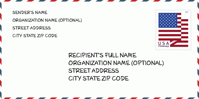
58018-9604 نمونه پاکت

-
این نمونه ای از پاکت نامه ایالات متحده است. اطلاعات فرستنده را در بالا سمت چپ و اطلاعات گیرنده را در پایین سمت راست وارد کنید. اطلاعات لازم نام کامل فرستنده/گیرنده ، آدرس خیابان ، شهر ، ایالت و کد پستی است. اطلاعات آدرس گیرنده برای مرجع شما داده شده است. به طور کلی ، اگر از کد پستی کامل 9 رقمی مطمئن نیستید ، فقط می توانید کد پستی 5 رقمی را پر کنید تا از دست دادن بسته جلوگیری شود.
58018-9604 معنای اساسی
-
هر رقم کد پستی 58018-9604 مخفف چیست؟ کد ZIP+4 از دو بخش تشکیل شده است، پنج رقم اول را می توان در اداره پست قرار داد، و چهار رقم آخر می تواند یک بخش جغرافیایی را در منطقه تحویل پنج رقمی مشخص کند. 6-7 رقم بخش یا چند بلوک را مشخص می کند و رقم 8-9 نشان دهنده بخش یا یک طرف خیابان است.
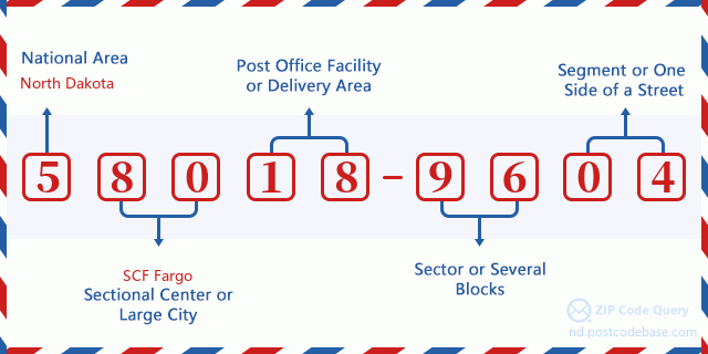

- ·شناسایی مسیر حامل?
A 4-digit code assigned to a mail delivery or collection route within a 5-digit ZIP Code. The first character of this identification is alphabetical, and the last three are numeric: Bnnn = PO box Hnnn = Highway contract Rnnn = Rural route Cnnn = City delivery Gnnn = General delivery: R001 (مسیر روستایی)
- ·بخش پایین افزونه فشرده?
The ZIP Add-On Low Sector and the ZIP Add-On Low Segment together form the ZIP Add-On Low Number. The ZIP Add-On Low Number is the last four positions of a ZIP+4 code; the low-end ZIP add-on in a range of codes; the add-on of the first ZIP+4 code in a consecutive series of ZIP+4 codes assigned to the delivery address. For example, most delivery addresses are assigned a single ZIP+4 code. However, large companies may be given a range of ZIP+4 codes that can be used to route mail to specific departments. A range of ZIP+4 codes can also be assigned to a corresponding range of post office boxes, and each box is mapped, one-to-one, with a ZIP+4 code in the range. A single post office box can also be assigned a range of ZIP+4 codes.: 96
- ·بخش پایین افزونه فشرده?
The ZIP Add-On Low Sector and the ZIP Add-On Low Segment together form the ZIP Add-On Low Number. The ZIP Add-On Low Number is the last four positions of a ZIP+4 code; the low-end ZIP add-on in a range of codes; the add-on of the first ZIP+4 code in a consecutive series of ZIP+4 codes assigned to the delivery address. For example, most delivery addresses are assigned a single ZIP+4 code. However, large companies may be given a range of ZIP+4 codes that can be used to route mail to specific departments. A range of ZIP+4 codes can also be assigned to a corresponding range of post office boxes, and each box is mapped, one-to-one, with a ZIP+4 code in the range. A single post office box can also be assigned a range of ZIP+4 codes.: 04
- ·بخش بالا افزونه فشرده?
The ZIP Add-On High Sector and the ZIP Add-On High Segment together form the ZIP Add-On High Number, which is the high-end ZIP add-on in a range of codes; the add-on of the last ZIP+4 code in a consecutive series of ZIP+4 codes assigned to the delivery address. Most delivery addresses are assigned a single ZIP+4 code; however, large companies may be given a range of ZIP+4 codes that can be used to route mail to specific departments. A range of ZIP+4 codes can also be assigned to a corresponding range of post office boxes, and each box is mapped, one-to-one, with a ZIP+4 code in the range. A single post office box can also be assigned a range of ZIP+4 codes. (See also ZIP Add-On Code.): 96
- ·بخش بالا افزونه فشرده?
The ZIP Add-On High Sector and the ZIP Add-On High Segment together form the ZIP Add-On High Number, which is the high-end ZIP add-on in a range of codes; the add-on of the last ZIP+4 code in a consecutive series of ZIP+4 codes assigned to the delivery address. Most delivery addresses are assigned a single ZIP+4 code; however, large companies may be given a range of ZIP+4 codes that can be used to route mail to specific departments. A range of ZIP+4 codes can also be assigned to a corresponding range of post office boxes, and each box is mapped, one-to-one, with a ZIP+4 code in the range. A single post office box can also be assigned a range of ZIP+4 codes. (See also ZIP Add-On Code.): 04
- ·کد پستی افزونه: 9604
- ·محدوده?
The range of +4 codes. Summing the +4 Code and the +4 Range will give you the high end of the range of +4 Codes that pertain to this ZIP Code.: 0
- ·کد متناوب پایه?
Code that specifies whether a record is a base (preferred) or alternate record. Base records (represented as "B") can represent a range of addresses or an individual address, such as a firm record, while alternate records (represented as "A") are individual delivery points. Government deliveries will only be listed on alternate records with the appropriate government building indicator (federal, state, or city) set.: پایه
- ·شماره مالی?
A code assigned to Postal Service facilities (primarily post offices) to collect cost and statistical data and compile revenue and expense data. The state number comprises the first two positions of the finance number.: 371872
- ·شماره ناحیه کنگره?
A standard value identifying a geographic area within the United States served by a member of the US House of Representatives or Senate. If Army/Air Force (APO) or fleet post office (FPO), this column will be blank. If there is only one member of Congress within a state, the code will be "AL" (at large).: AL
- ·کلید دولتی خط نهایی ترجیحی?
An index to the City State file that provides the preferred last-line name for this address range.: W18825
نقشه آنلاین

این نقشه آنلاین آدرس 6400 172ND AVE, COLFAX است. برای حرکت و زوم میتوانید از دکمه استفاده کنید. اطلاعات نقشه تنها برای مرجع است.
نشانی: 6400 (From 6400 To 6499) 172ND AVE SE (Southeast), COLFAX, ND 58018-9604, USA
دیدگاه


افزودن دیدگاه جدید