Adres: 2100 (From 2100 To 2199) 15TH AVE NE (Northeast), ANAMOOSE, ND 58710-9677, USA
Co to jest 58710-9677? 58710-9677 to kod pocztowy 5 Plus 4 liczba 2100 (From 2100 To 2199) 15TH AVE NE (Northeast), ANAMOOSE, ND, USA. Bliższe informacje poniżej.
58710-9677 Podstawowe informacje

-
Kod Pocztowy 5 Plus 4:
58710-9677 -
Kod Pocztowy 5:
58710 -
Plus 4?96774-digits that are used to identify a geographic segment within the 5-digit delivery area, such as a city block or a group of apartments or an individual high-volume receiver of mail, or any other unit that could use an extra identifier to aid in efficient mail sorting and delivery. This code is the low end of the range of +4 Codes that pertain to this ZIP Code. ZIP+4 Codes associated with nondelivery areas are composed of valid ZIP sector numbers and "ND" for the ZIP segment number, for example 12345-12ND. Non-deliverable areas are areas to which the USPS does not deliver mail, such as vacant lots and land that borders railroad tracks. Mailers should not match an address identified as a nondelivery area. If you absolutely must have numeric characters in the Plus4Code column, you may treat "ND" values as "00" (zero zero).:
-
Kraj:
U.S. - Stany Zjednoczone -
Państwo/stan:
ND - Dakota Północna -
Hrabstwo:
CountyFIPS: 38083 - Sheridan County -
Miasto:
ANAMOOSE -
Ulica?15TH AVEThe official name of a street as assigned by a local governing authority. The Street Name column contains only the street name and does not include directionals (EAST, WEST, etc.) or suffixes (ST, DR, BLVD, etc.). This element may also contain literals, such as PO BOX, GENERAL DELIVERY, USS, PSC, or UNIT. Numeric street names that have numeric components that are four characters (or less) in length at are justified such that the low-order digit of the number is positioned in the fourth position of the street name column. This shift is made so that the numeric street names appear in numeric sequence.:
-
Sufiks Ulicy?AVE (Ulica)The street suffix: For Example: ST = Street RD = Road DR = Drive LN = Lane:
-
Pokierunkowy Ulicy?NE (Northeast)A geographic direction that precedes the street name. For Example: 472 MAIN ST N Street Pre-Direction Abbreviation = N Spaces = No pre-direction N = North NE = Northeast E = East SE = Southeast S = South SW = Southwest W = West NW = Northwest:
-
Rodzaj Danych?S: UlicaAn alphabetic value that identifies the type of data in the record. Record type codes include the following: G = General delivery H = Highrise F = Firm S = Street P = PO box R = Rural route/highway contract:
Adres

- Prymarny Niski Numer Adresu?
A house, rural route, highway contract box, or post office box number; the numeric or alphanumeric component of an address preceding the street name; the low-end address in a range of addresses. Often referred to as house number.: 2100
- Prymarny Wysoki Numer Adresu?
A house, rural route, contract box, or Post Office box number. The numeric or alphanumeric component of an address preceding the street name. The high-end address in a range of addresses. Often referred to as house number.: 2199
- Nieparzysty/Parzysty Kod Prymarny Adresu?
Code that identifies the side or sides of a street for which a given address range is applicable. For street, highrise, firm and multi-carrier records, B = Both sides of a street, E = Even side of a street (even-numbered addresses in the range); O = Odd side of a street (odd-numbered addresses in the range). For general delivery, post office box, and rural route/highway contract records, this code will always be "B" (both).: Both of Odd and Even
- Podstawowy Zakres: 2100, 2101, 2102, 2103, 2104, 2105, 2106, 2107, 2108, 2109, 2110, 2111, 2112, 2113, 2114, 2115, 2116, 2117, 2118, 2119, 2120, 2121, 2122, 2123, 2124, 2125, 2126, 2127, 2128, 2129, 2130, 2131, 2132, 2133, 2134, 2135, 2136, 2137, 2138, 2139, 2140, 2141, 2142, 2143, 2144, 2145, 2146, 2147, 2148, 2149, 2150, 2151, 2152, 2153, 2154, 2155, 2156, 2157, 2158, 2159, 2160, 2161, 2162, 2163, 2164, 2165, 2166, 2167, 2168, 2169, 2170, 2171, 2172, 2173, 2174, 2175, 2176, 2177, 2178, 2179, 2180, 2181, 2182, 2183, 2184, 2185, 2186, 2187, 2188, 2189, 2190, 2191, 2192, 2193, 2194, 2195, 2196, 2197, 2198, 2199.
Kliknij "Więcej przykładów adresów", aby wyświetlić całą listę.
2100 15TH AVE NE (Northeast), ANAMOOSE, ND 58710-9677
2101 15TH AVE NE (Northeast), ANAMOOSE, ND 58710-9677
2102 15TH AVE NE (Northeast), ANAMOOSE, ND 58710-9677
2103 15TH AVE NE (Northeast), ANAMOOSE, ND 58710-9677
2104 15TH AVE NE (Northeast), ANAMOOSE, ND 58710-9677
2105 15TH AVE NE (Northeast), ANAMOOSE, ND 58710-9677
2106 15TH AVE NE (Northeast), ANAMOOSE, ND 58710-9677
2107 15TH AVE NE (Northeast), ANAMOOSE, ND 58710-9677
2108 15TH AVE NE (Northeast), ANAMOOSE, ND 58710-9677
2109 15TH AVE NE (Northeast), ANAMOOSE, ND 58710-9677
2110 15TH AVE NE (Northeast), ANAMOOSE, ND 58710-9677
2111 15TH AVE NE (Northeast), ANAMOOSE, ND 58710-9677
2112 15TH AVE NE (Northeast), ANAMOOSE, ND 58710-9677
2113 15TH AVE NE (Northeast), ANAMOOSE, ND 58710-9677
2114 15TH AVE NE (Northeast), ANAMOOSE, ND 58710-9677
2115 15TH AVE NE (Northeast), ANAMOOSE, ND 58710-9677
2116 15TH AVE NE (Northeast), ANAMOOSE, ND 58710-9677
2117 15TH AVE NE (Northeast), ANAMOOSE, ND 58710-9677
2118 15TH AVE NE (Northeast), ANAMOOSE, ND 58710-9677
2119 15TH AVE NE (Northeast), ANAMOOSE, ND 58710-9677
2120 15TH AVE NE (Northeast), ANAMOOSE, ND 58710-9677
2121 15TH AVE NE (Northeast), ANAMOOSE, ND 58710-9677
2122 15TH AVE NE (Northeast), ANAMOOSE, ND 58710-9677
2123 15TH AVE NE (Northeast), ANAMOOSE, ND 58710-9677
2124 15TH AVE NE (Northeast), ANAMOOSE, ND 58710-9677
2125 15TH AVE NE (Northeast), ANAMOOSE, ND 58710-9677
2126 15TH AVE NE (Northeast), ANAMOOSE, ND 58710-9677
2127 15TH AVE NE (Northeast), ANAMOOSE, ND 58710-9677
2128 15TH AVE NE (Northeast), ANAMOOSE, ND 58710-9677
2129 15TH AVE NE (Northeast), ANAMOOSE, ND 58710-9677
2130 15TH AVE NE (Northeast), ANAMOOSE, ND 58710-9677
2131 15TH AVE NE (Northeast), ANAMOOSE, ND 58710-9677
2132 15TH AVE NE (Northeast), ANAMOOSE, ND 58710-9677
2133 15TH AVE NE (Northeast), ANAMOOSE, ND 58710-9677
2134 15TH AVE NE (Northeast), ANAMOOSE, ND 58710-9677
2135 15TH AVE NE (Northeast), ANAMOOSE, ND 58710-9677
2136 15TH AVE NE (Northeast), ANAMOOSE, ND 58710-9677
2137 15TH AVE NE (Northeast), ANAMOOSE, ND 58710-9677
2138 15TH AVE NE (Northeast), ANAMOOSE, ND 58710-9677
2139 15TH AVE NE (Northeast), ANAMOOSE, ND 58710-9677
2140 15TH AVE NE (Northeast), ANAMOOSE, ND 58710-9677
2141 15TH AVE NE (Northeast), ANAMOOSE, ND 58710-9677
2142 15TH AVE NE (Northeast), ANAMOOSE, ND 58710-9677
2143 15TH AVE NE (Northeast), ANAMOOSE, ND 58710-9677
2144 15TH AVE NE (Northeast), ANAMOOSE, ND 58710-9677
2145 15TH AVE NE (Northeast), ANAMOOSE, ND 58710-9677
2146 15TH AVE NE (Northeast), ANAMOOSE, ND 58710-9677
2147 15TH AVE NE (Northeast), ANAMOOSE, ND 58710-9677
2148 15TH AVE NE (Northeast), ANAMOOSE, ND 58710-9677
2149 15TH AVE NE (Northeast), ANAMOOSE, ND 58710-9677
2150 15TH AVE NE (Northeast), ANAMOOSE, ND 58710-9677
2151 15TH AVE NE (Northeast), ANAMOOSE, ND 58710-9677
2152 15TH AVE NE (Northeast), ANAMOOSE, ND 58710-9677
2153 15TH AVE NE (Northeast), ANAMOOSE, ND 58710-9677
2154 15TH AVE NE (Northeast), ANAMOOSE, ND 58710-9677
2155 15TH AVE NE (Northeast), ANAMOOSE, ND 58710-9677
2156 15TH AVE NE (Northeast), ANAMOOSE, ND 58710-9677
2157 15TH AVE NE (Northeast), ANAMOOSE, ND 58710-9677
2158 15TH AVE NE (Northeast), ANAMOOSE, ND 58710-9677
2159 15TH AVE NE (Northeast), ANAMOOSE, ND 58710-9677
2160 15TH AVE NE (Northeast), ANAMOOSE, ND 58710-9677
2161 15TH AVE NE (Northeast), ANAMOOSE, ND 58710-9677
2162 15TH AVE NE (Northeast), ANAMOOSE, ND 58710-9677
2163 15TH AVE NE (Northeast), ANAMOOSE, ND 58710-9677
2164 15TH AVE NE (Northeast), ANAMOOSE, ND 58710-9677
2165 15TH AVE NE (Northeast), ANAMOOSE, ND 58710-9677
2166 15TH AVE NE (Northeast), ANAMOOSE, ND 58710-9677
2167 15TH AVE NE (Northeast), ANAMOOSE, ND 58710-9677
2168 15TH AVE NE (Northeast), ANAMOOSE, ND 58710-9677
2169 15TH AVE NE (Northeast), ANAMOOSE, ND 58710-9677
2170 15TH AVE NE (Northeast), ANAMOOSE, ND 58710-9677
2171 15TH AVE NE (Northeast), ANAMOOSE, ND 58710-9677
2172 15TH AVE NE (Northeast), ANAMOOSE, ND 58710-9677
2173 15TH AVE NE (Northeast), ANAMOOSE, ND 58710-9677
2174 15TH AVE NE (Northeast), ANAMOOSE, ND 58710-9677
2175 15TH AVE NE (Northeast), ANAMOOSE, ND 58710-9677
2176 15TH AVE NE (Northeast), ANAMOOSE, ND 58710-9677
2177 15TH AVE NE (Northeast), ANAMOOSE, ND 58710-9677
2178 15TH AVE NE (Northeast), ANAMOOSE, ND 58710-9677
2179 15TH AVE NE (Northeast), ANAMOOSE, ND 58710-9677
2180 15TH AVE NE (Northeast), ANAMOOSE, ND 58710-9677
2181 15TH AVE NE (Northeast), ANAMOOSE, ND 58710-9677
2182 15TH AVE NE (Northeast), ANAMOOSE, ND 58710-9677
2183 15TH AVE NE (Northeast), ANAMOOSE, ND 58710-9677
2184 15TH AVE NE (Northeast), ANAMOOSE, ND 58710-9677
2185 15TH AVE NE (Northeast), ANAMOOSE, ND 58710-9677
2186 15TH AVE NE (Northeast), ANAMOOSE, ND 58710-9677
2187 15TH AVE NE (Northeast), ANAMOOSE, ND 58710-9677
2188 15TH AVE NE (Northeast), ANAMOOSE, ND 58710-9677
2189 15TH AVE NE (Northeast), ANAMOOSE, ND 58710-9677
2190 15TH AVE NE (Northeast), ANAMOOSE, ND 58710-9677
2191 15TH AVE NE (Northeast), ANAMOOSE, ND 58710-9677
2192 15TH AVE NE (Northeast), ANAMOOSE, ND 58710-9677
2193 15TH AVE NE (Northeast), ANAMOOSE, ND 58710-9677
2194 15TH AVE NE (Northeast), ANAMOOSE, ND 58710-9677
2195 15TH AVE NE (Northeast), ANAMOOSE, ND 58710-9677
2196 15TH AVE NE (Northeast), ANAMOOSE, ND 58710-9677
2197 15TH AVE NE (Northeast), ANAMOOSE, ND 58710-9677
2198 15TH AVE NE (Northeast), ANAMOOSE, ND 58710-9677
2199 15TH AVE NE (Northeast), ANAMOOSE, ND 58710-9677
Adres Przykład
ANAMOOSE ND 58710-9677
UNITED STATES OF AMERICA
58710-9677 Przykład Koperty

-
To jest przykład koperty amerykańskiej. Wpisz informacje o nadawcy w lewym górnym rogu i informacje o odbiorcy w prawym dolnym rogu. Niezbędne informacje to imię i nazwisko nadawcy/odbiorcy, adres, miasto, województwo i kod pocztowy. Dane adresowe odbiorcy zostały podane w celach informacyjnych. Ogólnie rzecz biorąc, jeśli nie masz pewności co do pełnego 9-cyfrowego kodu pocztowego, możesz wpisać tylko 5-cyfrowy kod pocztowy, aby uniknąć utraty paczki.
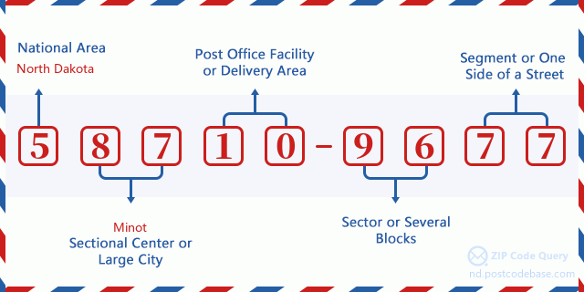
58710-9677 Podstawowe znaczenie
-
Co oznacza każda cyfra kodu pocztowego 58710-9677? Kod pocztowy + 4 składa się z dwóch części, pierwsze pięć cyfr może znajdować się w urzędzie pocztowym, a ostatnie cztery cyfry mogą identyfikować segment geograficzny w pięciocyfrowym obszarze dostawy. Cyfry 6-7 oznaczają sektor lub kilka bloków, a cyfry 8-9 oznaczają odcinek lub jedną stronę ulicy.

- ·ID Trasy Dostawy?
A 4-digit code assigned to a mail delivery or collection route within a 5-digit ZIP Code. The first character of this identification is alphabetical, and the last three are numeric: Bnnn = PO box Hnnn = Highway contract Rnnn = Rural route Cnnn = City delivery Gnnn = General delivery: R004 (Droga Wiejska)
- ·Sektor Niski ZIP Dodatku?
The ZIP Add-On Low Sector and the ZIP Add-On Low Segment together form the ZIP Add-On Low Number. The ZIP Add-On Low Number is the last four positions of a ZIP+4 code; the low-end ZIP add-on in a range of codes; the add-on of the first ZIP+4 code in a consecutive series of ZIP+4 codes assigned to the delivery address. For example, most delivery addresses are assigned a single ZIP+4 code. However, large companies may be given a range of ZIP+4 codes that can be used to route mail to specific departments. A range of ZIP+4 codes can also be assigned to a corresponding range of post office boxes, and each box is mapped, one-to-one, with a ZIP+4 code in the range. A single post office box can also be assigned a range of ZIP+4 codes.: 96
- ·Segment Niski ZIP Dodatku?
The ZIP Add-On Low Sector and the ZIP Add-On Low Segment together form the ZIP Add-On Low Number. The ZIP Add-On Low Number is the last four positions of a ZIP+4 code; the low-end ZIP add-on in a range of codes; the add-on of the first ZIP+4 code in a consecutive series of ZIP+4 codes assigned to the delivery address. For example, most delivery addresses are assigned a single ZIP+4 code. However, large companies may be given a range of ZIP+4 codes that can be used to route mail to specific departments. A range of ZIP+4 codes can also be assigned to a corresponding range of post office boxes, and each box is mapped, one-to-one, with a ZIP+4 code in the range. A single post office box can also be assigned a range of ZIP+4 codes.: 77
- ·Sektor Wysoki ZIP Dodatku?
The ZIP Add-On High Sector and the ZIP Add-On High Segment together form the ZIP Add-On High Number, which is the high-end ZIP add-on in a range of codes; the add-on of the last ZIP+4 code in a consecutive series of ZIP+4 codes assigned to the delivery address. Most delivery addresses are assigned a single ZIP+4 code; however, large companies may be given a range of ZIP+4 codes that can be used to route mail to specific departments. A range of ZIP+4 codes can also be assigned to a corresponding range of post office boxes, and each box is mapped, one-to-one, with a ZIP+4 code in the range. A single post office box can also be assigned a range of ZIP+4 codes. (See also ZIP Add-On Code.): 96
- ·Segment Wysoki ZIP Dodatku?
The ZIP Add-On High Sector and the ZIP Add-On High Segment together form the ZIP Add-On High Number, which is the high-end ZIP add-on in a range of codes; the add-on of the last ZIP+4 code in a consecutive series of ZIP+4 codes assigned to the delivery address. Most delivery addresses are assigned a single ZIP+4 code; however, large companies may be given a range of ZIP+4 codes that can be used to route mail to specific departments. A range of ZIP+4 codes can also be assigned to a corresponding range of post office boxes, and each box is mapped, one-to-one, with a ZIP+4 code in the range. A single post office box can also be assigned a range of ZIP+4 codes. (See also ZIP Add-On Code.): 77
- ·PNA Dodatek: 9677
- ·Zakres?
The range of +4 codes. Summing the +4 Code and the +4 Range will give you the high end of the range of +4 Codes that pertain to this ZIP Code.: 0
- ·Kod Alternatywny Bazy?
Code that specifies whether a record is a base (preferred) or alternate record. Base records (represented as "B") can represent a range of addresses or an individual address, such as a firm record, while alternate records (represented as "A") are individual delivery points. Government deliveries will only be listed on alternate records with the appropriate government building indicator (federal, state, or city) set.: Baza
- ·Numer Finansowy?
A code assigned to Postal Service facilities (primarily post offices) to collect cost and statistical data and compile revenue and expense data. The state number comprises the first two positions of the finance number.: 370288
- ·Numer Dystryktu Kongresowego?
A standard value identifying a geographic area within the United States served by a member of the US House of Representatives or Senate. If Army/Air Force (APO) or fleet post office (FPO), this column will be blank. If there is only one member of Congress within a state, the code will be "AL" (at large).: AL
- ·Preferowany Klucz Miasta Stanu Ostatniej Linii?
An index to the City State file that provides the preferred last-line name for this address range.: W18720
Mapa

To mapa sieciowa adresu 2100 15TH AVE, ANAMOOSE. Mapę można przybliżyć. Mapa przeznaczona jest wyłącznie dla celów informacyjnych.
Adres: 2100 (From 2100 To 2199) 15TH AVE NE (Northeast), ANAMOOSE, ND 58710-9677, USA
Komentarz


Dodaj komentarz