عنوان: 17300 (From 17300 To 17399) COUNTY ROAD 4, COLFAX, ND 58018-9607, USA
ما هو 58018-9607؟ إنه 58018-9607هو 17300 (From 17300 To 17399) COUNTY ROAD 4, COLFAX, ND, USA 5 أضاف4 الرمز البريدي. معلومات التفاصيل علي نحو التالي.
58018-9607 معلومات اساسية

-
الرمز البريدي 5 زائد 4:
58018-9607 -
الرمز البريدي 5:
58018 -
بالإضافة إلى 4?96074-digits that are used to identify a geographic segment within the 5-digit delivery area, such as a city block or a group of apartments or an individual high-volume receiver of mail, or any other unit that could use an extra identifier to aid in efficient mail sorting and delivery. This code is the low end of the range of +4 Codes that pertain to this ZIP Code. ZIP+4 Codes associated with nondelivery areas are composed of valid ZIP sector numbers and "ND" for the ZIP segment number, for example 12345-12ND. Non-deliverable areas are areas to which the USPS does not deliver mail, such as vacant lots and land that borders railroad tracks. Mailers should not match an address identified as a nondelivery area. If you absolutely must have numeric characters in the Plus4Code column, you may treat "ND" values as "00" (zero zero).:
-
بلد:
U.S. - الولايات المتحدة -
حالة:
ND - داكوتا الشمالية -
مقاطعة:
CountyFIPS: 38077 - Richland County -
مدينة:
COLFAX -
شارع?COUNTY ROAD 4The official name of a street as assigned by a local governing authority. The Street Name column contains only the street name and does not include directionals (EAST, WEST, etc.) or suffixes (ST, DR, BLVD, etc.). This element may also contain literals, such as PO BOX, GENERAL DELIVERY, USS, PSC, or UNIT. Numeric street names that have numeric components that are four characters (or less) in length at are justified such that the low-order digit of the number is positioned in the fourth position of the street name column. This shift is made so that the numeric street names appear in numeric sequence.:
-
نوع السجل?S: شارعAn alphabetic value that identifies the type of data in the record. Record type codes include the following: G = General delivery H = Highrise F = Firm S = Street P = PO box R = Rural route/highway contract:
عنوان

- الرقم المنخفض من العنوان الرئيسي ?
A house, rural route, highway contract box, or post office box number; the numeric or alphanumeric component of an address preceding the street name; the low-end address in a range of addresses. Often referred to as house number.: 17300
- الرقم العالي من العنوان الرئيسي?
A house, rural route, contract box, or Post Office box number. The numeric or alphanumeric component of an address preceding the street name. The high-end address in a range of addresses. Often referred to as house number.: 17399
- رمز فردي من العنوان الرئيسي/رمز زوجي?
Code that identifies the side or sides of a street for which a given address range is applicable. For street, highrise, firm and multi-carrier records, B = Both sides of a street, E = Even side of a street (even-numbered addresses in the range); O = Odd side of a street (odd-numbered addresses in the range). For general delivery, post office box, and rural route/highway contract records, this code will always be "B" (both).: Both of Odd and Even
- ابتدائي نطاق: 17300, 17301, 17302, 17303, 17304, 17305, 17306, 17307, 17308, 17309, 17310, 17311, 17312, 17313, 17314, 17315, 17316, 17317, 17318, 17319, 17320, 17321, 17322, 17323, 17324, 17325, 17326, 17327, 17328, 17329, 17330, 17331, 17332, 17333, 17334, 17335, 17336, 17337, 17338, 17339, 17340, 17341, 17342, 17343, 17344, 17345, 17346, 17347, 17348, 17349, 17350, 17351, 17352, 17353, 17354, 17355, 17356, 17357, 17358, 17359, 17360, 17361, 17362, 17363, 17364, 17365, 17366, 17367, 17368, 17369, 17370, 17371, 17372, 17373, 17374, 17375, 17376, 17377, 17378, 17379, 17380, 17381, 17382, 17383, 17384, 17385, 17386, 17387, 17388, 17389, 17390, 17391, 17392, 17393, 17394, 17395, 17396, 17397, 17398, 17399.
الرجاء النقر فوق "المزيد من أمثلة العنوان" لعرض القائمة بأكملها.
17300 COUNTY ROAD 4, COLFAX, ND 58018-9607
17301 COUNTY ROAD 4, COLFAX, ND 58018-9607
17302 COUNTY ROAD 4, COLFAX, ND 58018-9607
17303 COUNTY ROAD 4, COLFAX, ND 58018-9607
17304 COUNTY ROAD 4, COLFAX, ND 58018-9607
17305 COUNTY ROAD 4, COLFAX, ND 58018-9607
17306 COUNTY ROAD 4, COLFAX, ND 58018-9607
17307 COUNTY ROAD 4, COLFAX, ND 58018-9607
17308 COUNTY ROAD 4, COLFAX, ND 58018-9607
17309 COUNTY ROAD 4, COLFAX, ND 58018-9607
17310 COUNTY ROAD 4, COLFAX, ND 58018-9607
17311 COUNTY ROAD 4, COLFAX, ND 58018-9607
17312 COUNTY ROAD 4, COLFAX, ND 58018-9607
17313 COUNTY ROAD 4, COLFAX, ND 58018-9607
17314 COUNTY ROAD 4, COLFAX, ND 58018-9607
17315 COUNTY ROAD 4, COLFAX, ND 58018-9607
17316 COUNTY ROAD 4, COLFAX, ND 58018-9607
17317 COUNTY ROAD 4, COLFAX, ND 58018-9607
17318 COUNTY ROAD 4, COLFAX, ND 58018-9607
17319 COUNTY ROAD 4, COLFAX, ND 58018-9607
17320 COUNTY ROAD 4, COLFAX, ND 58018-9607
17321 COUNTY ROAD 4, COLFAX, ND 58018-9607
17322 COUNTY ROAD 4, COLFAX, ND 58018-9607
17323 COUNTY ROAD 4, COLFAX, ND 58018-9607
17324 COUNTY ROAD 4, COLFAX, ND 58018-9607
17325 COUNTY ROAD 4, COLFAX, ND 58018-9607
17326 COUNTY ROAD 4, COLFAX, ND 58018-9607
17327 COUNTY ROAD 4, COLFAX, ND 58018-9607
17328 COUNTY ROAD 4, COLFAX, ND 58018-9607
17329 COUNTY ROAD 4, COLFAX, ND 58018-9607
17330 COUNTY ROAD 4, COLFAX, ND 58018-9607
17331 COUNTY ROAD 4, COLFAX, ND 58018-9607
17332 COUNTY ROAD 4, COLFAX, ND 58018-9607
17333 COUNTY ROAD 4, COLFAX, ND 58018-9607
17334 COUNTY ROAD 4, COLFAX, ND 58018-9607
17335 COUNTY ROAD 4, COLFAX, ND 58018-9607
17336 COUNTY ROAD 4, COLFAX, ND 58018-9607
17337 COUNTY ROAD 4, COLFAX, ND 58018-9607
17338 COUNTY ROAD 4, COLFAX, ND 58018-9607
17339 COUNTY ROAD 4, COLFAX, ND 58018-9607
17340 COUNTY ROAD 4, COLFAX, ND 58018-9607
17341 COUNTY ROAD 4, COLFAX, ND 58018-9607
17342 COUNTY ROAD 4, COLFAX, ND 58018-9607
17343 COUNTY ROAD 4, COLFAX, ND 58018-9607
17344 COUNTY ROAD 4, COLFAX, ND 58018-9607
17345 COUNTY ROAD 4, COLFAX, ND 58018-9607
17346 COUNTY ROAD 4, COLFAX, ND 58018-9607
17347 COUNTY ROAD 4, COLFAX, ND 58018-9607
17348 COUNTY ROAD 4, COLFAX, ND 58018-9607
17349 COUNTY ROAD 4, COLFAX, ND 58018-9607
17350 COUNTY ROAD 4, COLFAX, ND 58018-9607
17351 COUNTY ROAD 4, COLFAX, ND 58018-9607
17352 COUNTY ROAD 4, COLFAX, ND 58018-9607
17353 COUNTY ROAD 4, COLFAX, ND 58018-9607
17354 COUNTY ROAD 4, COLFAX, ND 58018-9607
17355 COUNTY ROAD 4, COLFAX, ND 58018-9607
17356 COUNTY ROAD 4, COLFAX, ND 58018-9607
17357 COUNTY ROAD 4, COLFAX, ND 58018-9607
17358 COUNTY ROAD 4, COLFAX, ND 58018-9607
17359 COUNTY ROAD 4, COLFAX, ND 58018-9607
17360 COUNTY ROAD 4, COLFAX, ND 58018-9607
17361 COUNTY ROAD 4, COLFAX, ND 58018-9607
17362 COUNTY ROAD 4, COLFAX, ND 58018-9607
17363 COUNTY ROAD 4, COLFAX, ND 58018-9607
17364 COUNTY ROAD 4, COLFAX, ND 58018-9607
17365 COUNTY ROAD 4, COLFAX, ND 58018-9607
17366 COUNTY ROAD 4, COLFAX, ND 58018-9607
17367 COUNTY ROAD 4, COLFAX, ND 58018-9607
17368 COUNTY ROAD 4, COLFAX, ND 58018-9607
17369 COUNTY ROAD 4, COLFAX, ND 58018-9607
17370 COUNTY ROAD 4, COLFAX, ND 58018-9607
17371 COUNTY ROAD 4, COLFAX, ND 58018-9607
17372 COUNTY ROAD 4, COLFAX, ND 58018-9607
17373 COUNTY ROAD 4, COLFAX, ND 58018-9607
17374 COUNTY ROAD 4, COLFAX, ND 58018-9607
17375 COUNTY ROAD 4, COLFAX, ND 58018-9607
17376 COUNTY ROAD 4, COLFAX, ND 58018-9607
17377 COUNTY ROAD 4, COLFAX, ND 58018-9607
17378 COUNTY ROAD 4, COLFAX, ND 58018-9607
17379 COUNTY ROAD 4, COLFAX, ND 58018-9607
17380 COUNTY ROAD 4, COLFAX, ND 58018-9607
17381 COUNTY ROAD 4, COLFAX, ND 58018-9607
17382 COUNTY ROAD 4, COLFAX, ND 58018-9607
17383 COUNTY ROAD 4, COLFAX, ND 58018-9607
17384 COUNTY ROAD 4, COLFAX, ND 58018-9607
17385 COUNTY ROAD 4, COLFAX, ND 58018-9607
17386 COUNTY ROAD 4, COLFAX, ND 58018-9607
17387 COUNTY ROAD 4, COLFAX, ND 58018-9607
17388 COUNTY ROAD 4, COLFAX, ND 58018-9607
17389 COUNTY ROAD 4, COLFAX, ND 58018-9607
17390 COUNTY ROAD 4, COLFAX, ND 58018-9607
17391 COUNTY ROAD 4, COLFAX, ND 58018-9607
17392 COUNTY ROAD 4, COLFAX, ND 58018-9607
17393 COUNTY ROAD 4, COLFAX, ND 58018-9607
17394 COUNTY ROAD 4, COLFAX, ND 58018-9607
17395 COUNTY ROAD 4, COLFAX, ND 58018-9607
17396 COUNTY ROAD 4, COLFAX, ND 58018-9607
17397 COUNTY ROAD 4, COLFAX, ND 58018-9607
17398 COUNTY ROAD 4, COLFAX, ND 58018-9607
17399 COUNTY ROAD 4, COLFAX, ND 58018-9607
عنوان مثال
COLFAX ND 58018-9607
UNITED STATES OF AMERICA
58018-9607 مثال المغلف

-
هذا مثال على مغلف الولايات المتحدة. املأ معلومات المرسل في أعلى اليسار ومعلومات المستلم في أسفل اليمين. المعلومات الضرورية هي الاسم الكامل للمرسل / المستلم وعنوان الشارع والمدينة والولاية والرمز البريدي. تم تقديم معلومات عنوان المستلم كمرجع لك. بشكل عام ، إذا لم تكن متأكدًا من الرمز البريدي الكامل المكون من 9 أرقام ، فيمكنك فقط ملء الرمز البريدي المكون من 5 أرقام لتجنب فقد الحزمة.
58018-9607 المعنى الأساسي
-
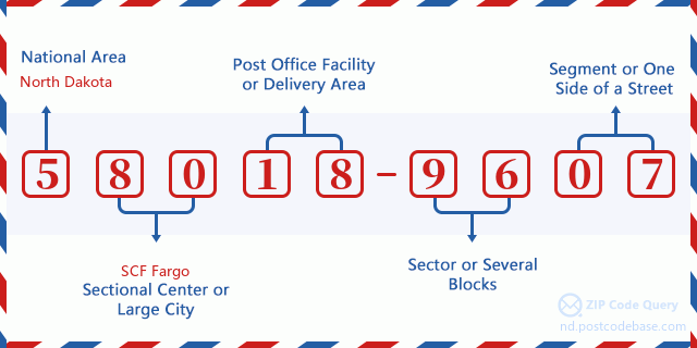
ما الذي يرمز إليه كل رقم في الرمز البريدي 58018-9607؟ يتكون الرمز البريدي + 4 من جزأين ، يمكن تحديد موقع أول خمسة أرقام في مكتب البريد ، ويمكن للأرقام الأربعة الأخيرة تحديد مقطع جغرافي داخل منطقة التسليم المكونة من خمسة أرقام. تحدد الأرقام المكونة من 6 إلى 7 أرقام قطاعًا أو عدة كتل ، بينما تحدد الأرقام المكونة من 8 إلى 9 أرقام مقطعًا أو جانبًا واحدًا من الشارع.

- ·طرق النقل ID?
A 4-digit code assigned to a mail delivery or collection route within a 5-digit ZIP Code. The first character of this identification is alphabetical, and the last three are numeric: Bnnn = PO box Hnnn = Highway contract Rnnn = Rural route Cnnn = City delivery Gnnn = General delivery: R001 (المسار الريفية)
- ·أضاف البريد علي قطاع منخفضة?
The ZIP Add-On Low Sector and the ZIP Add-On Low Segment together form the ZIP Add-On Low Number. The ZIP Add-On Low Number is the last four positions of a ZIP+4 code; the low-end ZIP add-on in a range of codes; the add-on of the first ZIP+4 code in a consecutive series of ZIP+4 codes assigned to the delivery address. For example, most delivery addresses are assigned a single ZIP+4 code. However, large companies may be given a range of ZIP+4 codes that can be used to route mail to specific departments. A range of ZIP+4 codes can also be assigned to a corresponding range of post office boxes, and each box is mapped, one-to-one, with a ZIP+4 code in the range. A single post office box can also be assigned a range of ZIP+4 codes.: 96
- ·أضاف البريد علي جزء منخفضة?
The ZIP Add-On Low Sector and the ZIP Add-On Low Segment together form the ZIP Add-On Low Number. The ZIP Add-On Low Number is the last four positions of a ZIP+4 code; the low-end ZIP add-on in a range of codes; the add-on of the first ZIP+4 code in a consecutive series of ZIP+4 codes assigned to the delivery address. For example, most delivery addresses are assigned a single ZIP+4 code. However, large companies may be given a range of ZIP+4 codes that can be used to route mail to specific departments. A range of ZIP+4 codes can also be assigned to a corresponding range of post office boxes, and each box is mapped, one-to-one, with a ZIP+4 code in the range. A single post office box can also be assigned a range of ZIP+4 codes.: 07
- ·أضاف البريد علي قطاع عالية?
The ZIP Add-On High Sector and the ZIP Add-On High Segment together form the ZIP Add-On High Number, which is the high-end ZIP add-on in a range of codes; the add-on of the last ZIP+4 code in a consecutive series of ZIP+4 codes assigned to the delivery address. Most delivery addresses are assigned a single ZIP+4 code; however, large companies may be given a range of ZIP+4 codes that can be used to route mail to specific departments. A range of ZIP+4 codes can also be assigned to a corresponding range of post office boxes, and each box is mapped, one-to-one, with a ZIP+4 code in the range. A single post office box can also be assigned a range of ZIP+4 codes. (See also ZIP Add-On Code.): 96
- ·أضاف البريد علي جزء عالية?
The ZIP Add-On High Sector and the ZIP Add-On High Segment together form the ZIP Add-On High Number, which is the high-end ZIP add-on in a range of codes; the add-on of the last ZIP+4 code in a consecutive series of ZIP+4 codes assigned to the delivery address. Most delivery addresses are assigned a single ZIP+4 code; however, large companies may be given a range of ZIP+4 codes that can be used to route mail to specific departments. A range of ZIP+4 codes can also be assigned to a corresponding range of post office boxes, and each box is mapped, one-to-one, with a ZIP+4 code in the range. A single post office box can also be assigned a range of ZIP+4 codes. (See also ZIP Add-On Code.): 07
- ·الرمز البريدي ملحق: 9607
- ·نطاق?
The range of +4 codes. Summing the +4 Code and the +4 Range will give you the high end of the range of +4 Codes that pertain to this ZIP Code.: 0
- ·رمز البديل الأساسي?
Code that specifies whether a record is a base (preferred) or alternate record. Base records (represented as "B") can represent a range of addresses or an individual address, such as a firm record, while alternate records (represented as "A") are individual delivery points. Government deliveries will only be listed on alternate records with the appropriate government building indicator (federal, state, or city) set.: قاعدة
- ·الأرقام المالية?
A code assigned to Postal Service facilities (primarily post offices) to collect cost and statistical data and compile revenue and expense data. The state number comprises the first two positions of the finance number.: 371872
- ·رقم منطقة الكونغرس?
A standard value identifying a geographic area within the United States served by a member of the US House of Representatives or Senate. If Army/Air Force (APO) or fleet post office (FPO), this column will be blank. If there is only one member of Congress within a state, the code will be "AL" (at large).: AL
- ·رمز المدينة المفضلة الأخير?
An index to the City State file that provides the preferred last-line name for this address range.: W18825
خريطة الانترنت

هذا هو عنوان 17300 COUNTY ROAD 4 COLFAX مطابقة الخريطة الإلكترونية عبر الإنترنت يمكنك استخدام زر في الخريطة للتحرك وتكبير. معلومات الخريطة هي للإشارة فقط.
عنوان: 17300 (From 17300 To 17399) COUNTY ROAD 4, COLFAX, ND 58018-9607, USA
التعليق


إضافة تعليق جديد