地址: 17300 (From 17300 To 17399) COUNTY ROAD 4, COLFAX, ND 58018-9607, USA
58018-9607是什麼 58018-9607是 17300 (From 17300 To 17399) COUNTY ROAD 4, COLFAX, ND, USA的5加4位邮编。下面是详细信息。
58018-9607基本信息

-
郵政編碼5加4:
58018-9607 -
郵政編碼5:
58018 -
加4?96074-digits that are used to identify a geographic segment within the 5-digit delivery area, such as a city block or a group of apartments or an individual high-volume receiver of mail, or any other unit that could use an extra identifier to aid in efficient mail sorting and delivery. This code is the low end of the range of +4 Codes that pertain to this ZIP Code. ZIP+4 Codes associated with nondelivery areas are composed of valid ZIP sector numbers and "ND" for the ZIP segment number, for example 12345-12ND. Non-deliverable areas are areas to which the USPS does not deliver mail, such as vacant lots and land that borders railroad tracks. Mailers should not match an address identified as a nondelivery area. If you absolutely must have numeric characters in the Plus4Code column, you may treat "ND" values as "00" (zero zero).:
-
國家:
U.S. - 美國 -
州:
ND - 北達科他州 -
區縣:
CountyFIPS: 38077 - Richland County -
城市:
COLFAX -
街道?COUNTY ROAD 4The official name of a street as assigned by a local governing authority. The Street Name column contains only the street name and does not include directionals (EAST, WEST, etc.) or suffixes (ST, DR, BLVD, etc.). This element may also contain literals, such as PO BOX, GENERAL DELIVERY, USS, PSC, or UNIT. Numeric street names that have numeric components that are four characters (or less) in length at are justified such that the low-order digit of the number is positioned in the fourth position of the street name column. This shift is made so that the numeric street names appear in numeric sequence.:
-
記錄類型?S: 街道An alphabetic value that identifies the type of data in the record. Record type codes include the following: G = General delivery H = Highrise F = Firm S = Street P = PO box R = Rural route/highway contract:
地址

- 主要地址地位數字?
A house, rural route, highway contract box, or post office box number; the numeric or alphanumeric component of an address preceding the street name; the low-end address in a range of addresses. Often referred to as house number.: 17300
- 主要地址高位數字?
A house, rural route, contract box, or Post Office box number. The numeric or alphanumeric component of an address preceding the street name. The high-end address in a range of addresses. Often referred to as house number.: 17399
- 主要地址奇/偶碼?
Code that identifies the side or sides of a street for which a given address range is applicable. For street, highrise, firm and multi-carrier records, B = Both sides of a street, E = Even side of a street (even-numbered addresses in the range); O = Odd side of a street (odd-numbered addresses in the range). For general delivery, post office box, and rural route/highway contract records, this code will always be "B" (both).: Both of Odd and Even
- 主要範圍: 17300, 17301, 17302, 17303, 17304, 17305, 17306, 17307, 17308, 17309, 17310, 17311, 17312, 17313, 17314, 17315, 17316, 17317, 17318, 17319, 17320, 17321, 17322, 17323, 17324, 17325, 17326, 17327, 17328, 17329, 17330, 17331, 17332, 17333, 17334, 17335, 17336, 17337, 17338, 17339, 17340, 17341, 17342, 17343, 17344, 17345, 17346, 17347, 17348, 17349, 17350, 17351, 17352, 17353, 17354, 17355, 17356, 17357, 17358, 17359, 17360, 17361, 17362, 17363, 17364, 17365, 17366, 17367, 17368, 17369, 17370, 17371, 17372, 17373, 17374, 17375, 17376, 17377, 17378, 17379, 17380, 17381, 17382, 17383, 17384, 17385, 17386, 17387, 17388, 17389, 17390, 17391, 17392, 17393, 17394, 17395, 17396, 17397, 17398, 17399.
請單擊"更多地址示例"查看整個列表。
17300 COUNTY ROAD 4, COLFAX, ND 58018-9607
17301 COUNTY ROAD 4, COLFAX, ND 58018-9607
17302 COUNTY ROAD 4, COLFAX, ND 58018-9607
17303 COUNTY ROAD 4, COLFAX, ND 58018-9607
17304 COUNTY ROAD 4, COLFAX, ND 58018-9607
17305 COUNTY ROAD 4, COLFAX, ND 58018-9607
17306 COUNTY ROAD 4, COLFAX, ND 58018-9607
17307 COUNTY ROAD 4, COLFAX, ND 58018-9607
17308 COUNTY ROAD 4, COLFAX, ND 58018-9607
17309 COUNTY ROAD 4, COLFAX, ND 58018-9607
17310 COUNTY ROAD 4, COLFAX, ND 58018-9607
17311 COUNTY ROAD 4, COLFAX, ND 58018-9607
17312 COUNTY ROAD 4, COLFAX, ND 58018-9607
17313 COUNTY ROAD 4, COLFAX, ND 58018-9607
17314 COUNTY ROAD 4, COLFAX, ND 58018-9607
17315 COUNTY ROAD 4, COLFAX, ND 58018-9607
17316 COUNTY ROAD 4, COLFAX, ND 58018-9607
17317 COUNTY ROAD 4, COLFAX, ND 58018-9607
17318 COUNTY ROAD 4, COLFAX, ND 58018-9607
17319 COUNTY ROAD 4, COLFAX, ND 58018-9607
17320 COUNTY ROAD 4, COLFAX, ND 58018-9607
17321 COUNTY ROAD 4, COLFAX, ND 58018-9607
17322 COUNTY ROAD 4, COLFAX, ND 58018-9607
17323 COUNTY ROAD 4, COLFAX, ND 58018-9607
17324 COUNTY ROAD 4, COLFAX, ND 58018-9607
17325 COUNTY ROAD 4, COLFAX, ND 58018-9607
17326 COUNTY ROAD 4, COLFAX, ND 58018-9607
17327 COUNTY ROAD 4, COLFAX, ND 58018-9607
17328 COUNTY ROAD 4, COLFAX, ND 58018-9607
17329 COUNTY ROAD 4, COLFAX, ND 58018-9607
17330 COUNTY ROAD 4, COLFAX, ND 58018-9607
17331 COUNTY ROAD 4, COLFAX, ND 58018-9607
17332 COUNTY ROAD 4, COLFAX, ND 58018-9607
17333 COUNTY ROAD 4, COLFAX, ND 58018-9607
17334 COUNTY ROAD 4, COLFAX, ND 58018-9607
17335 COUNTY ROAD 4, COLFAX, ND 58018-9607
17336 COUNTY ROAD 4, COLFAX, ND 58018-9607
17337 COUNTY ROAD 4, COLFAX, ND 58018-9607
17338 COUNTY ROAD 4, COLFAX, ND 58018-9607
17339 COUNTY ROAD 4, COLFAX, ND 58018-9607
17340 COUNTY ROAD 4, COLFAX, ND 58018-9607
17341 COUNTY ROAD 4, COLFAX, ND 58018-9607
17342 COUNTY ROAD 4, COLFAX, ND 58018-9607
17343 COUNTY ROAD 4, COLFAX, ND 58018-9607
17344 COUNTY ROAD 4, COLFAX, ND 58018-9607
17345 COUNTY ROAD 4, COLFAX, ND 58018-9607
17346 COUNTY ROAD 4, COLFAX, ND 58018-9607
17347 COUNTY ROAD 4, COLFAX, ND 58018-9607
17348 COUNTY ROAD 4, COLFAX, ND 58018-9607
17349 COUNTY ROAD 4, COLFAX, ND 58018-9607
17350 COUNTY ROAD 4, COLFAX, ND 58018-9607
17351 COUNTY ROAD 4, COLFAX, ND 58018-9607
17352 COUNTY ROAD 4, COLFAX, ND 58018-9607
17353 COUNTY ROAD 4, COLFAX, ND 58018-9607
17354 COUNTY ROAD 4, COLFAX, ND 58018-9607
17355 COUNTY ROAD 4, COLFAX, ND 58018-9607
17356 COUNTY ROAD 4, COLFAX, ND 58018-9607
17357 COUNTY ROAD 4, COLFAX, ND 58018-9607
17358 COUNTY ROAD 4, COLFAX, ND 58018-9607
17359 COUNTY ROAD 4, COLFAX, ND 58018-9607
17360 COUNTY ROAD 4, COLFAX, ND 58018-9607
17361 COUNTY ROAD 4, COLFAX, ND 58018-9607
17362 COUNTY ROAD 4, COLFAX, ND 58018-9607
17363 COUNTY ROAD 4, COLFAX, ND 58018-9607
17364 COUNTY ROAD 4, COLFAX, ND 58018-9607
17365 COUNTY ROAD 4, COLFAX, ND 58018-9607
17366 COUNTY ROAD 4, COLFAX, ND 58018-9607
17367 COUNTY ROAD 4, COLFAX, ND 58018-9607
17368 COUNTY ROAD 4, COLFAX, ND 58018-9607
17369 COUNTY ROAD 4, COLFAX, ND 58018-9607
17370 COUNTY ROAD 4, COLFAX, ND 58018-9607
17371 COUNTY ROAD 4, COLFAX, ND 58018-9607
17372 COUNTY ROAD 4, COLFAX, ND 58018-9607
17373 COUNTY ROAD 4, COLFAX, ND 58018-9607
17374 COUNTY ROAD 4, COLFAX, ND 58018-9607
17375 COUNTY ROAD 4, COLFAX, ND 58018-9607
17376 COUNTY ROAD 4, COLFAX, ND 58018-9607
17377 COUNTY ROAD 4, COLFAX, ND 58018-9607
17378 COUNTY ROAD 4, COLFAX, ND 58018-9607
17379 COUNTY ROAD 4, COLFAX, ND 58018-9607
17380 COUNTY ROAD 4, COLFAX, ND 58018-9607
17381 COUNTY ROAD 4, COLFAX, ND 58018-9607
17382 COUNTY ROAD 4, COLFAX, ND 58018-9607
17383 COUNTY ROAD 4, COLFAX, ND 58018-9607
17384 COUNTY ROAD 4, COLFAX, ND 58018-9607
17385 COUNTY ROAD 4, COLFAX, ND 58018-9607
17386 COUNTY ROAD 4, COLFAX, ND 58018-9607
17387 COUNTY ROAD 4, COLFAX, ND 58018-9607
17388 COUNTY ROAD 4, COLFAX, ND 58018-9607
17389 COUNTY ROAD 4, COLFAX, ND 58018-9607
17390 COUNTY ROAD 4, COLFAX, ND 58018-9607
17391 COUNTY ROAD 4, COLFAX, ND 58018-9607
17392 COUNTY ROAD 4, COLFAX, ND 58018-9607
17393 COUNTY ROAD 4, COLFAX, ND 58018-9607
17394 COUNTY ROAD 4, COLFAX, ND 58018-9607
17395 COUNTY ROAD 4, COLFAX, ND 58018-9607
17396 COUNTY ROAD 4, COLFAX, ND 58018-9607
17397 COUNTY ROAD 4, COLFAX, ND 58018-9607
17398 COUNTY ROAD 4, COLFAX, ND 58018-9607
17399 COUNTY ROAD 4, COLFAX, ND 58018-9607
地址範例
COLFAX ND 58018-9607
UNITED STATES OF AMERICA
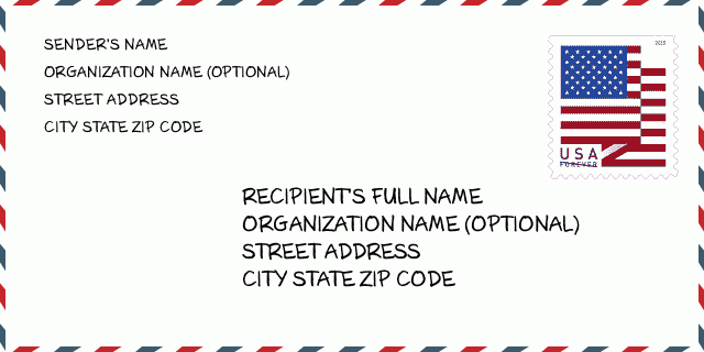
58018-9607信封例子

-
這是美國信封例子。在左上角填寫發件人信息,右下角填寫收件人信息。必須要填寫的信息有發件人和收件人的姓名、街道地址、城市、州還有郵政編碼。收件人的地址示例僅供參考。通常來說,如果你不確定九位郵件,你可以僅僅填寫五位郵編,以避免郵件丟失。
58018-9607基本含義
-
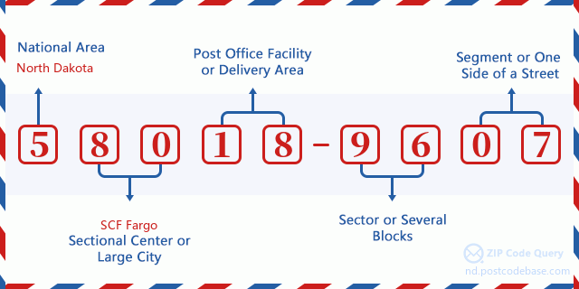
郵政編碼 58018-9607 的每個數字代表什麼?ZIP+4 Code由兩部分組成,前五位數字可以定位到郵局,後四位數字可以確定五位數字遞送區域內的一個地理區段。 6-7位數字指定區域或幾個街區,8-9位數字指定區段或街道的一側。

- ·運輸路線ID?
A 4-digit code assigned to a mail delivery or collection route within a 5-digit ZIP Code. The first character of this identification is alphabetical, and the last three are numeric: Bnnn = PO box Hnnn = Highway contract Rnnn = Rural route Cnnn = City delivery Gnnn = General delivery: R001 (農村路線)
- ·郵遞附加低部?
The ZIP Add-On Low Sector and the ZIP Add-On Low Segment together form the ZIP Add-On Low Number. The ZIP Add-On Low Number is the last four positions of a ZIP+4 code; the low-end ZIP add-on in a range of codes; the add-on of the first ZIP+4 code in a consecutive series of ZIP+4 codes assigned to the delivery address. For example, most delivery addresses are assigned a single ZIP+4 code. However, large companies may be given a range of ZIP+4 codes that can be used to route mail to specific departments. A range of ZIP+4 codes can also be assigned to a corresponding range of post office boxes, and each box is mapped, one-to-one, with a ZIP+4 code in the range. A single post office box can also be assigned a range of ZIP+4 codes.: 96
- ·郵遞附加低段?
The ZIP Add-On Low Sector and the ZIP Add-On Low Segment together form the ZIP Add-On Low Number. The ZIP Add-On Low Number is the last four positions of a ZIP+4 code; the low-end ZIP add-on in a range of codes; the add-on of the first ZIP+4 code in a consecutive series of ZIP+4 codes assigned to the delivery address. For example, most delivery addresses are assigned a single ZIP+4 code. However, large companies may be given a range of ZIP+4 codes that can be used to route mail to specific departments. A range of ZIP+4 codes can also be assigned to a corresponding range of post office boxes, and each box is mapped, one-to-one, with a ZIP+4 code in the range. A single post office box can also be assigned a range of ZIP+4 codes.: 07
- ·郵遞附加高部?
The ZIP Add-On High Sector and the ZIP Add-On High Segment together form the ZIP Add-On High Number, which is the high-end ZIP add-on in a range of codes; the add-on of the last ZIP+4 code in a consecutive series of ZIP+4 codes assigned to the delivery address. Most delivery addresses are assigned a single ZIP+4 code; however, large companies may be given a range of ZIP+4 codes that can be used to route mail to specific departments. A range of ZIP+4 codes can also be assigned to a corresponding range of post office boxes, and each box is mapped, one-to-one, with a ZIP+4 code in the range. A single post office box can also be assigned a range of ZIP+4 codes. (See also ZIP Add-On Code.): 96
- ·郵遞附加高段?
The ZIP Add-On High Sector and the ZIP Add-On High Segment together form the ZIP Add-On High Number, which is the high-end ZIP add-on in a range of codes; the add-on of the last ZIP+4 code in a consecutive series of ZIP+4 codes assigned to the delivery address. Most delivery addresses are assigned a single ZIP+4 code; however, large companies may be given a range of ZIP+4 codes that can be used to route mail to specific departments. A range of ZIP+4 codes can also be assigned to a corresponding range of post office boxes, and each box is mapped, one-to-one, with a ZIP+4 code in the range. A single post office box can also be assigned a range of ZIP+4 codes. (See also ZIP Add-On Code.): 07
- ·郵政編碼附加: 9607
- ·範圍?
The range of +4 codes. Summing the +4 Code and the +4 Range will give you the high end of the range of +4 Codes that pertain to this ZIP Code.: 0
- ·基本替代代碼?
Code that specifies whether a record is a base (preferred) or alternate record. Base records (represented as "B") can represent a range of addresses or an individual address, such as a firm record, while alternate records (represented as "A") are individual delivery points. Government deliveries will only be listed on alternate records with the appropriate government building indicator (federal, state, or city) set.: 基本
- ·財務數字?
A code assigned to Postal Service facilities (primarily post offices) to collect cost and statistical data and compile revenue and expense data. The state number comprises the first two positions of the finance number.: 371872
- ·國會分區號碼?
A standard value identifying a geographic area within the United States served by a member of the US House of Representatives or Senate. If Army/Air Force (APO) or fleet post office (FPO), this column will be blank. If there is only one member of Congress within a state, the code will be "AL" (at large).: AL
- ·最後行市州代碼?
An index to the City State file that provides the preferred last-line name for this address range.: W18825
在線地圖

这是地址17300 COUNTY ROAD 4 COLFAX匹配的在线电子地图。您可以使用图中按钮来移动、缩放。该地图信息仅供参考。
地址: 17300 (From 17300 To 17399) COUNTY ROAD 4, COLFAX, ND 58018-9607, USA
回應


發表新回應